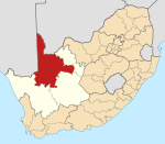
Place in Northern Cape, South Africa
| Grootdrink | |
|---|---|
  | |
| Coordinates: 28°33′40″S 21°44′49″E / 28.561°S 21.747°E / -28.561; 21.747 | |
| Country | South Africa |
| Province | Northern Cape |
| District | ZF Mgcawu |
| Municipality | !Kheis |
| Area | |
| • Total | 0.81 km (0.31 sq mi) |
| Population | |
| • Total | 2,645 |
| • Density | 3,300/km (8,500/sq mi) |
| Racial makeup (2011) | |
| • Black African | 2.2% |
| • Coloured | 89.4% |
| • Indian/Asian | 2.2% |
| • Other | 6.1% |
| First languages (2011) | |
| • Afrikaans | 96.7% |
| • English | 1.3% |
| • Other | 2.0% |
| Time zone | UTC+2 (SAST) |
| PO box | 8822 |
| Area code | 054 |
Grootdrink is a town in !Kheis Local Municipality in the Northern Cape province of South Africa on the N10 National Route and on the Orange River. The town is known as being the centre of wine production in the Northern Cape.
References
- ^ "Main Place Grootdrink". Census 2011.
- "Information on Golf, Activities, Restaurants And Accommodation In Grootdrink". Wheretostay. Retrieved 25 August 2013.
| Municipalities and communities of ZF Mgcawu District Municipality, Northern Cape | ||
|---|---|---|
| District seat: Upington | ||
| Dawid Kruiper |  | |
| Kai !Garib | ||
| Kgatelopele | ||
| !Kheis | ||
| Tsantsabane | ||
This Northern Cape location article is a stub. You can help Misplaced Pages by expanding it. |