| Gudar River Guder | |
|---|---|
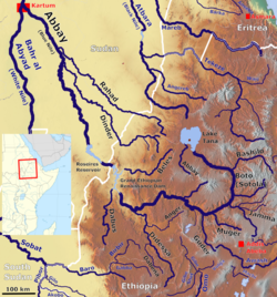
 Map showing the Abbay (Blue Nile) basin, with the Gudar River (bottom right) Map showing the Abbay (Blue Nile) basin, with the Gudar River (bottom right) | |
| Location | |
| Country | Ethiopia |
| Physical characteristics | |
| Mouth | Blue Nile |
| • coordinates | 9°51′49″N 37°40′16″E / 9.863615°N 37.671039°E / 9.863615; 37.671039 |
| • elevation | 932 m (3,058 ft) |
| Basin size | 7,011 km (2,707 sq mi) |
| Basin features | |
| Progression | Blue Nile → Nile → Mediterranean Sea |
| River system | Nile Basin |
The Gudar is a river of central Ethiopia. It is a left-bank tributary of the Abay or Blue Nile; tributaries of the Gudar include the Dabissa and the Taranta. The Gudar River has a drainage area about 7,011 square kilometers in size. It was bounded by the historical Endagabatan province.
In the 1600s, emperor Susenyos I and his troops traversed this river to meet Hadiya leader Sidi Mohammed at the Battle of Hadiya.
A Greek resident built the first bridge over the Gudar in 1897.
See also
Notes
- Abbay. Encyclopedia Aethiopica.
- "Tana & Beles Integrated Water Resources Development: Project Appraisal Document (PAD), Vol.1", World Bank, 2 May 2008 (accessed 5 May 2009)
- Endagabatan. Encyclopedia Aethiopica.
- Lindahl, Bernhard. Local History of Ethiopia (PDF). Nordic Africa Institute. p. 9.
- Richard Pankhurst, Economic History of Ethiopia (Addis Ababa: Haile Selassie University, 1968), p. 299
| Largest rivers of Ethiopia | |
|---|---|
| Rivers | |
This article related to a river in Ethiopia is a stub. You can help Misplaced Pages by expanding it. |