| Gurans Himal | |
|---|---|
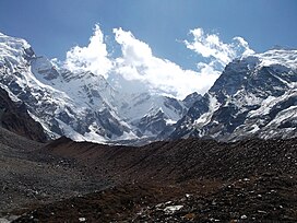
 Southern/western aspects of Api Southern/western aspects of Api | |
| Highest point | |
| Peak | Api |
| Elevation | 7,132 m (23,399 ft) |
| Coordinates | 30°00′15″N 80°56′00″E / 30.00417°N 80.93333°E / 30.00417; 80.93333 |
| Geography | |
 | |
| Country | Nepal |
| Parent range | Himalayas |
The Gurans Himal is a small subrange of the Himalayas in far western Nepal. It is little-known, since it does not contain any 8000 metre peaks, or even any peaks above 7,200 metres. Its highest peak is Api, 7,132 m (23,399 ft), which, despite its relatively low height compared to the major Himalayan peaks, rises dramatically from a low base, as do the other significant peaks of the Gurans Himal.
Carter's classification of the Himalayas divides the Gurans Himal into two subsections. The Saipal Subsection lies east of the Seti River, and its highest peak is Api, 7,132 m (23,399 ft). The Yoka Pahar Subsection lies west of the Seti, and contains Api, 7,132 m (23,399 ft); Jethi Bahurani, 6,850 m (22,474 ft); Bobaye, 6,808 m (22,336 ft); and Nampa, 6,755 m (22,162 ft), among other peaks.
References
- ^ Carter, H. Adams (1986). "Classification of the Himalaya". The Himalayan Journal. 42. The Himalayan Club. Retrieved 17 April 2019.
- ^ Neate, Jill (January 1990). High Asia: An Illustrated History of the 7000 Metre Peaks. Mountaineers Books. ISBN 978-0898862386.
External links
- Gurans Himal region marked on OpenStreetMap
This article related to a mountain or hill in Nepal is a stub. You can help Misplaced Pages by expanding it. |