| Hadrut District | |
|---|---|
| District | |
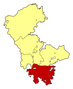
 Map of Hadrut within NKAO Map of Hadrut within NKAO | |
| Autonomous region | |
| Country | |
| Established | 8 August 1930 |
| Abolished | 26 November 1991 |
| Capital | Hadrut |
| Area | |
| • Total | 679 km (262 sq mi) |
| Population | |
| • Total | 14,200 |
Hadrut District (Azerbaijani: Hadrut rayonu; Armenian: Հադրութի շրջան, romanized: Hadrowt'i shrjan) was an administrative unit within the former Nagorno-Karabakh Autonomous Oblast (NKAO) of the Azerbaijan Soviet Socialist Republic.
History
The district was formed on 8 August 1930, as the Dizak district; it was renamed Hadrut District on 17 September 1939. The administrative center of the district was the town of Hadrut.
The total area of the district was 679 km and it included 41 villages (1986).
Along with NKAO, the district was abolished on 26 November 1991 and was incorporated into Khojavend District of Azerbaijan.
Following the First Nagorno-Karabakh war, the former district came under the control of the self-proclaimed Republic of Artsakh and was incorporated into its Hadrut Province. However, during the 2020 Nagorno-Karabakh war, Azerbaijan recaptured the town of Hadrut during the Battle of Hadrut, followed by the whole of the district.
Demographics
| Year | Population | Ethnic groups | Source |
|---|---|---|---|
| 1926 | 25,247 | 97.8% Armenians, 1.8% Azerbaijanis, 0.3% Russians | Soviet Census |
| 1939 | 27,128 | 95.7% Armenians, 2.7% Azerbaijanis, 1.3% Russians | Soviet Census |
| 1959 | 16,808 | 93.3% Armenians, 6.1% Azerbaijanis, 0.4% Russians | Soviet Census |
| 1970 | 15,937 | 87.5% Armenians, 10.4% Azerbaijanis, 0.9% Russians | Soviet Census |
| 1979 | 14,792 | 84.4% Armenians, 15.1% Azerbaijanis, 0.3% Russians | Soviet Census |
References
- ^ Баш редактор: Ҹ. Б. Гулијев, ed. (1987). "Һадрут рајону". Азәрбајҹан Совет Енсиклопедијасы: . Vol. X ҹилд: Фрост – Шүштəр. Бакы: Азәрбајҹан Совет Енсиклопедијасынын Баш Редаксиjасы. сәһ. 127.
- "Нагорно-Карабахская автономная область" [Nagorno-Karabakh Autonomous Oblast]. Great Soviet Encyclopedia (in Russian). 1967.
- Мельников С. А., Ибрагимов Ч. Г (1979). Азербайджанская ССР. Административно-территориальное деление на 1 января 1977 года. Baku: Азернешр. pp. 7–11.
- "Azərbaycan Respublikasının Dağlıq Qarabağ Muxtar Vilayətini ləğv etmək haqqında AZƏRBAYCAN RESPUBLİKASININ QANUNU" [Law of Azerbaijan Republic on Abolishment of Nagorno-Karabakh Autonomous Oblast of Azerbaijan Republic]. Archived from the original on 2012-04-24. Retrieved 2011-08-30.
- "Война в Карабахе, день 16-й: умозрительное перемирие и 96 погибших у армян" (in Russian). BBC Russian Service. 12 October 2020. Retrieved 21 October 2020.
- ^ "НАСЕЛЕНИЕ НАГОРНОГО КАРАБАХА". ethno-kavkaz.narod.ru (in Russian). Etno Kavkaz.
39°31′00″N 47°01′48″E / 39.51667°N 47.03000°E / 39.51667; 47.03000
Category: