Human settlement in England
| Hardendale | |
|---|---|
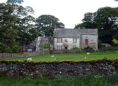
 Hardendale Hall Hardendale Hall | |
  | |
| OS grid reference | NY581146 |
| Civil parish | |
| Unitary authority | |
| Ceremonial county | |
| Region | |
| Country | England |
| Sovereign state | United Kingdom |
| Post town | PENRITH |
| Postcode district | CA10 |
| Dialling code | 01931 |
| Police | Cumbria |
| Fire | Cumbria |
| Ambulance | North West |
| UK Parliament | |
| 54°31′30″N 2°38′46″W / 54.525°N 2.646°W / 54.525; -2.646 | |
Hardendale is a hamlet in the parish of Shap Rural in Westmorland and Furness, in the county of Cumbria, England, near Shap and junction 39 of the M6 motorway. It is also near the hamlet of Oddendale.
References
This Cumbria location article is a stub. You can help Misplaced Pages by expanding it. |