Neighborhood of Los Angeles in California, United States
| Harvard Heights | |
|---|---|
| Neighborhood of Los Angeles | |
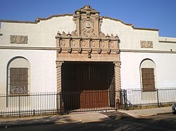
 The historic Spanish Colonial Revival style Pacific Bell Building, 2008 The historic Spanish Colonial Revival style Pacific Bell Building, 2008 | |
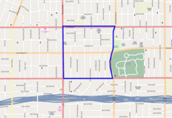
 Harvard Heights, as delineated by the Los Angeles Times Harvard Heights, as delineated by the Los Angeles Times | |
 | |
| Coordinates: 34°2′36″N 118°18′15″W / 34.04333°N 118.30417°W / 34.04333; -118.30417 | |
| Country | United States |
| State | California |
| County | Los Angeles |
| City | Los Angeles |
Harvard Heights is a neighborhood in Central Los Angeles, California. It lies within a municipally designated historic preservation overlay zone designed to protect its architecturally significant single-family residences, including the only remaining Greene and Greene house in Los Angeles.
There are five Los Angeles Historic-Cultural Monuments in the neighborhood, including a private library dedicated to the memory of singer Ray Charles.
History
Harvard Heights has been noted as a
once grand neighborhood that was in danger of falling apart. ... The overall population was old and largely African American as whites migrated to the suburbs, the freeway bisected the neighborhood, and most of the homes had been converted into apartments. ... neighborhood's long-anticipated renaissance took place in the late '90s. As Los Angeles commutes got longer and longer, white-collar professionals began moving back into the city.
Harvard Heights has been called a "preservationist's dream come true," a neighborhood characterized by the Craftsman houses built on the heights southwest of downtown, primarily between 1902 and 1910. Today, Harvard Heights boasts the only remaining Greene and Greene home in Los Angeles, "as well as homes built by the Heinemann brothers, Hunt and Eager, and especially architect Frank M. Tyler."
According to a 2005 Los Angeles Times headline, Harvard Heights was "a stately turn-of-the-century neighborhood that has been undergoing a restoration boom after decades of hard times. xquisite woodwork, high ceilings, formal dining rooms, cozy inglenooks and stained-glass windows are some of the features that attract residents to spacious two-story homes" found in the area."
In 2005 it was said that "Although prices are rising steadily, Harvard Heights remains an affordable choice for people interested in large historic homes. Two-story homes here are a relative bargain when the square footage and features are compared with similarly priced structures in other neighborhoods."
Exquisite woodwork, high ceilings, formal dining rooms, cozy inglenooks and stained-glass windows are some of the features that attract residents to these spacious two-story homes. For those who work downtown, the area's proximity to the city and the Santa Monica Freeway make it an easy commute.
The architecture of the neighborhood has also made the area a favorite for film and television location scouts.
Geography
According to the Los Angeles Times, Harvard Heights is located in the West Adams district and is bounded by Pico Boulevard on the north, Washington Boulevard on the south, Normandie Avenue on the east and Western Avenue on the west. It is bordered by Angelus Vista on the west, West Adams Heights on the south and the Byzantine-Latino Quarter is on the north.
Historic Preservation Overlay Zone

The Harvard Heights Historic Preservation Zone was adopted in 2000. It encompasses 34 blocks composed predominantly of single-family residences, some multiple-family residences, as well as commercial properties. The designated historic zone lies between Pico Boulevard on the north, Santa Monica Freeway to the south, Normandie Avenue on the east and Western Avenue on the west. The HPOZ includes both the neighborhood of Harvard Heights to the north of Washington Boulevard and the neighborhood of West Adams Heights to the south.
Population
| This section needs to be updated. Please help update this article to reflect recent events or newly available information. (April 2023) |
According to the Mapping L.A. project of the Los Angeles Times, the 2000 U.S. census counted 18,587 residents in the 0.79-square-mile neighborhood—an average of 23,473 people per square mile, one of the highest densities in Los Angeles. In 2008 the city estimated that the population had increased to 20,194. The median age for residents was 30, about the same as the city norm.
Harvard Heights was considered moderately diverse ethnically. In 2000, The breakdown was Latinos, 66.3%; Asians, 13.3%; blacks, 16%, whites, 3.3%; and others, 1.2%. Mexico (32.9%) and El Salvador (24.8%) were the most common places of birth for the 57.8% of the residents who were born abroad, a figure that was considered high compared to the city as a whole.
The median household income in 2008 dollars was $31,173, a low figure for Los Angeles, and a high percentage of households earned $20,000 or less. The average household size of 3.2 people was high for the city of Los Angeles. Renters occupied 84.3% of the housing units, and house- or apartment owners the rest.
The percentages of never-married men and women, 50% and 48,2%, respectively, were among the county's highest. The 2000 census found 939 families headed by single parents, a high rate for both the city and the county. There were 501 military veterans in 2000, or 3.8%, a low figure for Los Angeles. Just 10.3% of Harvard Heights residents aged 25 and older had a four-year degree in 2000, a low rate for both the city and the county. The percentage of residents with less than a high school diploma was high for the county.
Education

Schools operating within the Harvard Heights borders are:
- Los Angeles Elementary School, LAUSD, 1211 South Hobart Boulevard
- Bishop Conaty-Our Lady of Loretto High School, private, 2900 West Pico Boulevard
- The Jane B. Eisner School (New Camino Nuevo Charter), charter, 2755 W. 15th St. A middle school campus serving grades 6 through 8.
Historic-Cultural Monuments

There are five Los Angeles Historic-Cultural Monuments in Harvard Heights:
- Peet House - 1139 S. Harvard Boulevard. On September 21, 1983 it became Historic Cultural Monument #272
- Angelus-Rosedale Cemetery - 1831 W. Washington Boulevard. On December 1, 1987, it became Historic Cultural Monument #330.
- Pacific Bell Building - 2755 W. 15th Street. On December 8, 1987, it became Historic Cultural Monument #331. In February 2013, the Spanish Colonial-revival building was rehabilitated for adaptive reuse and reopened as the Jane B. Eisner charter middle school.
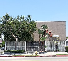
- Ray Charles's recording studio and office - 2107 W. Washington Boulevard. On January 21, 2004 it became Historic Cultural Monument #776. In September 2010, the original site of the singer recording studio was rededicated as the Ray Charles Memorial Library. The library contains exhibit space including memorabilia, awards, and interactive music displays.
- Julius Bierlich Residence - 1818 S. Gramercy Place. On September 27, 1994, it became Historic Cultural Monument #599.
- Lucy E. Wheeler Residence - 2175 Cambridge Street. It is Historic Cultural Monument #991. Designed by Greene and Greene, it is the last remaining example of the firm’s work in Los Angeles.
Business and commerce

The Byzantine-Latino Quarter is located at the northern edge of the neighborhood.
Notable residents
- William M. Hughes, Los Angeles City Council member, 1927–29
- Edward Trinkkeller, master ironworker and designer of the gates at Hearst Castle
- Frank M. Tyler, architect
- Lovie Yancey, founder of the Fatburger hamburger chain
- Ivy Pochoda, author
See also
References
- ^ Mothner, Linda Beth (September 12, 1993). "Harvard Heights: Love of Things Old Preserves Community (Map)". Los Angeles Times. p. K12. Retrieved February 23, 2023.
- ^ Roberts, Gretchen. "Star Treatment: A Picture-Perfect Hollywood Craftsman". Old House Journal. Archived from the original on August 27, 2013. Retrieved June 2, 2013.
- "Lucy E. Wheeler Residence". Los Angeles Conservancy. Archived from the original on April 15, 2013. Retrieved February 23, 2023.
{{cite web}}: CS1 maint: bot: original URL status unknown (link) - ^ Miller, Danny (September 11, 2005). "Saving Harvard Heights". Los Angeles Times. p. K2. Retrieved February 23, 2023.
- Mothner, Linda Beth (September 12, 1993). "Harvard Heights: Love of Things Old Preserves Community". Los Angeles Times. p. K12. Retrieved February 23, 2023.
...Harvard Heights formed the original tract for the West Adams District at the turn of the century....bounded by Pico Boulevard on the north, Washington Boulevard on the south, Normandie Avenue on the east and Western Avenue on the west.
- Dillon, Liam (August 1, 2023). "This L.A. developer aims to tear down homes". Los Angeles Times. Retrieved August 9, 2023.
....two-story Victorian in Harvard Heights in the West Adams district for $840,000.
- "Harvard Heights Historic Preservation Overlay Zone". LACIty.org. Retrieved February 23, 2023.
Harvard Heights HPOZ is predominantly characterized by two-story Craftsman-style residences built from 1902 to 1908. The large and somewhat grand scale of architecture is due to a land covenant that stipulated that houses built within the tract cost more than $2,500, a substantial sum at the turn of the century. The location of the only existing Greene and Greene designed house in the city of Los Angeles, the neighborhood also features the work of the famous Heineman brothers as well as notable West Adams architect Frank Tyler. The HPOZ boundaries include modest commercial buildings located along the edges of the neighborhood. The Harvard Heights HPOZ was adopted by City Council in 2000.
- ^ "Harvard Heights HPOZ" (PDF). December 9, 2010. p. 18 & 93. Retrieved March 5, 2021.
Stone marker placed by West Adams Heights tract realtors at Washington Boulevard.
- ^ "Harvard Heights Historic Preservation Overlay Zone Architectural Survey" (PDF). LACity.org. Retrieved March 5, 2021.
- ^ "Harvard Heights," Mapping L.A., Los Angeles Times
- ^ "Harvard Height Schools," Mapping L.A., Los Angeles Times
- Jane B. Eisner School Announcement . Retrieved on 2 June 2013.
- "Jane B. Eisner Middle School - Los Angeles - Brugklas". Facebook. Retrieved October 4, 2013.
- Pacific Bell Building Adaptive Reuse Project
- Goodman, Dean (October 1, 2010). "Ray Charles museum opens in L.A." NBC News. Retrieved October 29, 2022.
- "FAQs". The Ray Charles Memorial Library. September 23, 2010. Retrieved October 4, 2013.
- "Julius Bierlich ResidenceHistoric Resource". LACity.org. HistoricPlacesLA. Retrieved May 11, 2023.
- Macveen, Mary (June 12, 2010). "Greene & Greene for under $1 million". Los Angeles Times. Retrieved March 15, 2024.
The 2,620-square-foot house, designed in 1905 and expanded in 1917, sits on Cambridge Street in the area of West Adams known as Harvard Heights.
- "The Watchman," Los Angeles Times, April 24, 1927, page B-2
- Location on "Mapping L.A."
- Danny Miller, "Saving Harvard Heights: Old College Try Works," The Los Angeles Times, September 11, 2005
- "961 Marshall-Kline Residence | Flickr - Photo Sharing!". Flickr. April 30, 2011. Retrieved October 4, 2013.
- Pochoda, Ivy (July 2020). "Let the women do the talking: Behind the Book by Ivy Pochoda". Bookpage.com. Retrieved January 20, 2024.
I live in a neighborhood called Harvard Heights, a small subsection of a much larger neighborhood called West Adams
External links
- Los Angeles City Planning Office of Historic Resources: Harvard Heights
- Harvard Heights HPOZ Preservation Plan
- Los Angeles Historic Cultural Monument List
| By topic | |
|---|---|
| Government | |
| Los Angeles Historic Preservation Overlay Zones | ||
|---|---|---|
|  | |
| Places adjacent to Harvard Heights, Los Angeles | ||||||||||||||||
|---|---|---|---|---|---|---|---|---|---|---|---|---|---|---|---|---|
| ||||||||||||||||
