Misplaced Pages

Himalchuli

Article snapshot taken from[REDACTED] with creative commons attribution-sharealike license. Give it a read and then ask your questions in the chat. We can research this topic together.
Mountain in Nepal
Himalchuli
Himalchuli from south
Highest point
Elevation7,893 m (25,896 ft)
Ranked 18th
Prominence1,633 m (5,358 ft)
ListingUltra
Coordinates28°26′03″N 84°38′15″E / 28.43417°N 84.63750°E / 28.43417; 84.63750
Geography
Himalchuli is located in NepalHimalchuliHimalchuliLocation in Nepal
About OpenStreetMapsMaps: terms of use 45km
30miles Nepal Pakistan ChinaNgadi Chuli South 45Ngadi Chuli SouthAnnapurna IV 42Annapurna IVHimalchuli West 41Himalchuli WestAnnapurna III 40Annapurna IIISilver Crag 37Silver CragAnnapurna Fang 36Annapurna FangDhaulagiri IV 35Dhaulagiri IVGurla Mandhata (Naimona'nyi, Namu Nan) 32Gurla Mandhata (Naimona'nyi, Namu Nan)Dhaulagiri III 30Dhaulagiri IIIDhaulagiri II 28Dhaulagiri IIKamet 27KametNanda Devi 23Nanda DeviNgadi Chuli (Peak 29, Dakura, Dakum, Dunapurna) 21Ngadi Chuli (Peak 29, Dakura, Dakum, Dunapurna)Himalchuli (Himal Chuli) 20Himalchuli (Himal Chuli)Annapurna II 17Annapurna IIAnnapurna I East (Annapurna East Peak) 15Annapurna I East (Annapurna East Peak)Manaslu East 14Manaslu EastAnnapurna 12AnnapurnaNanga Parbat (Diamer) 11Nanga Parbat (Diamer)Manaslu (Kutang) 10Manaslu (Kutang)Dhaulagiri 9Dhaulagiri  The major peaks (not mountains) above 7,500 m (24,600 ft) height in Himalayas, rank identified in Himalayas alone (not the world). The map may help give context to Himalchuli with more detail and zooming on click through.

Legend:
1:Mount Everest,  2:Kangchenjunga,  3:Lhotse,  4:Yalung Kang, Kanchenjunga West,  5:Makalu,  6:Kangchenjunga South,  7:Kangchenjunga Central,  8:Cho Oyu,  9:Dhaulagiri,  10:Manaslu (Kutang),  11:Nanga Parbat (Diamer) ,  12:Annapurna,  13:Shishapangma (Shishasbangma, Xixiabangma),  14:Manaslu East,  15:Annapurna East Peak,  16: Gyachung Kang,  17:Annapurna II ,  18:Tenzing Peak (Ngojumba Kang, Ngozumpa Kang, Ngojumba Ri),  19:Kangbachen,  20:Himalchuli (Himal Chuli),  21:Ngadi Chuli (Peak 29, Dakura, Dakum, Dunapurna),  22:Nuptse (Nubtse),  23:Nanda Devi,  24:Chomo Lonzo (Chomolonzo, Chomolönzo, Chomo Lönzo, Jomolönzo, Lhamalangcho),  25:Namcha Barwa (Namchabarwa),  26:Zemu Kang (Zemu Gap Peak),  27:Kamet,  28:Dhaulagiri II,  29:Ngojumba Kang II,  30:Dhaulagiri III,  31:Kumbhakarna Mountain (Mount Kumbhakarna, Jannu),  32:Gurla Mandhata (Naimona'nyi, Namu Nan) ,  33:Hillary Peak (Ngojumba Kang III),  34:Molamenqing (Phola Gangchen),  35:Dhaulagiri IV,  36:Annapurna Fang,  37:Silver Crag,  38:Kangbachen Southwest,  39:Gangkhar Puensum (Gangkar Punsum),  40:Annapurna III,  41:Himalchuli West,  42:Annapurna IV,  43:Kula Kangri,  44:Liankang Kangri (Gangkhar Puensum North, Liangkang Kangri),  45:Ngadi Chuli South

 
Location in Nepal
LocationLamjung, Gorkha-Gandaki Province, Nepal
Parent rangeMansiri Himal, Himalayas
Climbing
First ascentMay 24, 1960 by Hisashi Tanabe, Masahiro Harada
Easiest routeglacier/snow/ice climb

Himalchuli (also sometimes written as two words, Himal Chuli) is the second-highest mountain in the Mansiri Himal, part of the Nepalese Himalayas, and the 18th-highest mountain in the world (using a cutoff of 500 meters prominence, or re-ascent). It lies south of Manaslu, one of the eight-thousanders. Himalchuli has three main peaks: East (7,893 m (25,896 ft)), West (7,540 m (24,740 ft)) and North (7,371 m (24,183 ft)).

Himalchuli is also notable for its large vertical relief over local terrain. For example, it rises 7,000 metres (23,000 feet) over the Marsyangdi River to the southwest in about 27 km (17 mi) horizontal distance.

Black and white image of Mount Himalchuli from the premise of Gorkha Durbar

.

Mt. Himalchuli is also notably seen from Chitwan as well.

Climbing history

Exploratory visits to the peak were made in 1950 and 1954, and a first attempt in 1955 failed early on. Further reconnaissance and attempts followed in 1958 and 1959.

The first ascent was made on May 24, 1960, by Hisashi Tanabe and Masahiro Harada, of Japan. The route followed the "Sickle Ridge" from the southwest. They first climbed to the saddle between the West and Main peaks, where they placed the last of six camps. This ascent was somewhat unusual for a sub-8000m peak in using bottled oxygen.

The Himalayan Index lists five other ascents of this peak, and 10 additional unsuccessful attempts. The ascents were by various routes on the south, southwest, and southeast sides of the mountain.
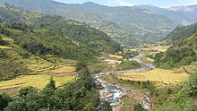
Dordi river

The West Peak was first climbed in 1978 by two members of a Japanese expedition to the main peak of Himalchuli. They climbed from the south (the Dordi Khola) and approached the summit of the West Peak from the east.

The North Peak was first climbed in 1985 by a Korean expedition, via the North Face.

References

  1. ^ "High Asia II: Himalaya of Nepal, Bhutan, Sikkim and adjoining region of Tibet". Peaklist.org. Retrieved 2014-05-30.
  2. "Peak Bagger:Himalaya, Central Nepal Himalaya, Khumbu, Ghurka Himal, Annapurna Himal, Xishapangma Area, Sikkim-Eastern Nepal Himalaya, Western Nepal Himalaya, Assam Himalaya, Punjab Himalaya, Bhutan Himalaya, Garwhal Himalaya, Ganesh Himal". Retrieved 22 October 2024.

Sources

Other references

Categories:
Himalchuli Add topic