| This article possibly contains original research. Please improve it by verifying the claims made and adding inline citations. Statements consisting only of original research should be removed. (February 2018) (Learn how and when to remove this message) |
| Holenarasipura Hole Narsipura | |
|---|---|
| Town | |
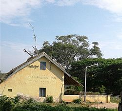
 Old Railway Station Old Railway Station | |
 | |
| Coordinates: 12°46′59″N 76°14′35″E / 12.783°N 76.243°E / 12.783; 76.243 | |
| Country | |
| State | Karnataka |
| District | Hassan |
| Government | |
| • Type | Town Municipal Council |
| • MLA | H. D. Revanna |
| Area | |
| • Town | 7.38 km (2.85 sq mi) |
| • Rural | 541.75 km (209.17 sq mi) |
| Elevation | 849 m (2,785 ft) |
| Population | |
| • Town | 29,938 |
| • Rural | 152,213 |
| Languages | |
| • Official | Kannada |
| Time zone | UTC+5:30 (IST) |
| PIN | 573 211 |
| Telephone code | +91-8175 |
| ISO 3166 code | IN-KA |
| Vehicle registration | KA-13 |
| Website | www |
Holenarasipura is a town and taluk in Hassan district of Karnataka. The town is situated on the banks of the Hemavati, one of the tributaries of the Kaveri.
Demographics
As of 2011 India census, Holenarasipura had a population of 29,938. Males constitute 51% of the population and females 49%. It has an average literacy rate of 73%, higher than the national average of 59.5%; with male literacy of 78% and female literacy of 68%. 11% of the population is under 6 years of age.
Geography
It is located at an elevation of 840 metres (2,760 ft), 33 km south of its district headquarters, Hassan. The taluk and the town are situated downstream of Gorur Dam, making it agriculturally rich. Main crops are Paddy and Tobacco. The region/taluk is also famous for its Cucumbers. Numerous highways pass through the town of Holenarasipura. They are NH-373, SH-57, SH-8, SH-102, SH-108, and SH-109. Holenarasipura is situated 85 km from Mysuru, 165 km from state capital Bengaluru and around 200 km from port city of Mangaluru, via NH-75.
Transportation
The town has two modes of transport; Road and Railways. Public transport is maintained by buses of KSRTC. It also houses a KSRTC Bus Depot under Hassan division. Holenarasipura railway is a single-line broad-gauge between Mysore-Hassan. It comes under Mysore division of South Western Railway Zone. It has railway connectivity to Mysore, Hassan, Bengaluru, Mangalore, Shivamogga, Hubli-Dharwad and Dadar via Davangere. Nearest international airports are Kannur International Airport and Kempegowda International Airport at 175 km and 195 km, respectively.
Places of attraction
- Belur & Halebeedu
- Gorur Dam
- Shravanabelagola
- Chunchanakatte Falls
- Manjarabad Fort
- Bisle ghat
- Mosale Sri Chennakeshava & Shiva temple
- Jenukallu Peak in Sakleshpura taluk
Gallery
-
 Positioning of Hassan district in Karnataka
-
 Hobli Map of Hassan district
-
 Map of Holenarasipura Taluk as per 2001 Census
-
 Map of Holenarasipura Taluk as per 2011 Census
-
 Holenarasipura Taluk - Hobli and Village Map
-
 Holenarasipura Taluk - Grama Panchayat and Village Map
-
 Holenarasipura Taluk Map about Fluoride content in DWS
Notable people
- Satchidanandendra Saraswati, philosopher, Advaita and Vedanta thinker.
- H. D. Deve Gowda, former Prime Minister.
- K. S. Ashwath, Kannada actor.
- Koundinya (Y. N. Nagesh), popular detective novelist in Kannada.
See also
- Saligrama, Mysore
- Ramanathapura
- Arkalgud
- Mangalore
- Keralapura
- Govindanahalli
- Kikkeri
- Panchalingeshwara Temple, Govindanahalli
References
- "Census Data Handbook 2011 Hassan District" (PDF). Retrieved 9 August 2023.