| Hopin ဟိုပင် | |
|---|---|
| Town | |
 | |
 | |
| Coordinates: 24°59′0″N 96°31′0″E / 24.98333°N 96.51667°E / 24.98333; 96.51667 | |
| Country | |
| Division | |
| District | Mohnyin District |
| Township | Mohnyin Township |
| Population | |
| • Religions | Buddhism Christianity |
| Time zone | UTC+6.30 (MST) |
| WOEID | 1017418 |

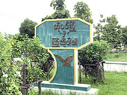
Hopin (Burmese: ဟိုပင်မြို့; Shan: ဝဵင်းႁူဝ်ပၢင်ႇ; also Hobin) is a town in Mohnyin Township, Kachin State, in north-east Myanmar. It is situated on the main Mandalay – Myitkyina railway line, 745 miles north from Yangon. It is on the road between Mohnyin and Mogaung where the road to Ywathit and Indawgyi Lake takes off. It is 27 miles by road from Indawgyi Lake and 60 miles by road from Sinbo which is located on the west bank of the Ayeyarwady River.
Notes
- "Indawgyi Lake Wildlife Sanctuary". Ministry of Ecotourism. Archived from the original on 2006-03-25. Retrieved 2008-12-25.
External links
- "Hopin Map — Satellite Images of Hopin" Maplandia World Gazetteer
| Kachin State | ||
|---|---|---|
| Capital: Myitkyina | ||
| Bhamo District |   | |
| Mohnyin District | ||
| Myitkyina District | ||
| Putao District | ||
| Main cities and towns | ||
This Kachin State location article is a stub. You can help Misplaced Pages by expanding it. |