| Huiva | |
|---|---|
 | |
 | |
| Location | |
| Country | Ukraine |
| Physical characteristics | |
| Mouth | Teteriv |
| • coordinates | 50°13′29″N 28°37′57″E / 50.2246°N 28.6326°E / 50.2246; 28.6326 |
| Length | 97 km (60 mi) |
| Basin size | 1,505 km (581 sq mi) |
| Basin features | |
| Progression | Teteriv→ Dnieper→ Dnieper–Bug estuary→ Black Sea |
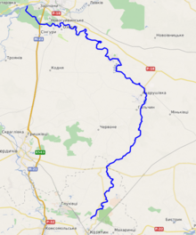
The Huiva (Ukrainian: Гуйва, Russian: Гуйва Guyva) is a river of northern Ukraine, flowing through the territory of Khmilnyk Raion of Vinnytsia Oblast and Andrushivka Raion and Zhytomyr Raion of Zhytomyr Oblast. It is a right tributary of the Teteriv.
The river has a length of 97 km and basin area of 1505 km ². The Huiva flows through the cities of Koziatyn and Andrushivka.
The biggest tributaries are: Pustoha, Kodenka.
References
- «Каталог річок України» — Видавництво АН УРСР, Київ, 1957.
This article about a location in Zhytomyr Oblast is a stub. You can help Misplaced Pages by expanding it. |
This article about a location in Vinnytsia Oblast is a stub. You can help Misplaced Pages by expanding it. |
This article related to a river in Ukraine is a stub. You can help Misplaced Pages by expanding it. |