| Jeesiö | |
|---|---|
| Village | |
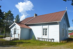
 A chapel in Jeesiö. A chapel in Jeesiö. | |
 | |
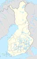
| Coordinates: 67°30.5575′N 26°02.2562′E / 67.5092917°N 26.0376033°E / 67.5092917; 26.0376033 | |
| Country | Finland |
| Region | Lapland |
| Municipality | Sodankylä |
| Time zone | UTC+2 (EET) |
| • Summer (DST) | UTC+3 (EEST) |
Jeesiö (Finnish pronunciation: [ˈjeːsiøˣ]) is a rural village in the Sodankylä municipality in Lapland, Finland. It is located along the Highway 80, about 30 kilometres (19 mi) west of the town centre towards Kittilä. About 130 residents live in the village's postal code area. There are still buildings left in the village from the early 20th century, as the village was not burned in the Lapland War by Germans, possibly due to poor transport connections.
The Kaarestunturi fell is located about 12 kilometres (7.5 mi) northeast of Jeesiö and a gravel road called Jeesiönratsutie leads there.
See also
Sources
Further reading
- Alajärvi, Paula (2014). Jeesiö : Virtamukasta Mikkolaan (in Finnish). Jeesiön kyläyhdistys. ISBN 978-952-93-4230-3.
References
- "Postinumeroalue 99770 kartalla". kuopassa.net (in Finnish). Retrieved 2 February 2024.
- ^ "Kylät" (in Finnish). Sodankylä. Retrieved 2 February 2024.
- "Kaarestunturi". Geocaching. Retrieved 2 February 2024.
External links
- Jeesiö's location at Fonecta
This Lapland (Finland) location article is a stub. You can help Misplaced Pages by expanding it. |