| Kaukausib | |
|---|---|
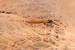
 Aerial view of Kaukausib source (2016) Aerial view of Kaukausib source (2016) | |
| Location | |
| Country | |
| Region | Karas |
| Physical characteristics | |
| Source | |
| • location | Kaukausus source |
| • coordinates | 26°59′15″S 15°38′58″E / 26.987512°S 15.649336°E / -26.987512; 15.649336 |

Kaukausib-River in German called Kaukausib-Mulde is a rivier (dry river) within the Diamond Restricted Area also called Sperrgebiet in the south of Namibia. The Kaukausib-Rivier extends through the Namib from south to north-north-west. It ends in the Namib Desert without reaching the Atlantic, or any other river. At the upper end of the Kaukausib Rivier there is a spring, which carries water throughout the whole year and is a drinking trough for various animals, especially for Oryx and Ostrich. The Kaukausib-spring is located 62 km southeast of Lüderitz and 40 km east of the Atlantic coast on 375 m above sea level (1235 ft).
In early days, on the march from Lüderitzbucht to Aus oxen were watered at the Kaukausib-well. The Germans write:
... und bald darauf war die Wasserstelle Kaukausib erfüllt von Lärm und Staub, von Gestampf und Ochsengebrüll.
— Meno Holst, Lüderitz erkämpft Südwest S.118 (1941)
In English it means:
... and soon the watering place Kaukausib was filled with noise and dust, with stamping and oxen bellowing.
— Meno Holst, Lüderitz erkämpft Südwest Page:118 (1941)
The book Diamonds in the Desert describes, how August Stauch established a company in the beginning of the 20th century called Kaukausibtal Diamantengesellschaft.

Pictures
References
- Kaukausib Rivier auf GetaMap.net
- Kaukausib-Mulde
- See German Page Rivier which in a local language means Dry-River.
- Namibia Travel Map. Kunth-Verlag, München 2017, ISBN 978-3-95504-578-4.
- Mapping the Major Catchments of Namibia. Ben J. Strohbach, National Botanical Research Institute, pp 5–6.
- Olga Levinson: Diamonds in the Desert. 2. Auflage, Kuiseb Verlag, Windhoek 2009, ISBN 978-99916-40-85-3.
- Field report Anib and Arasab pan – southern Namib Desert 27.-31.10.2019, Dr. Henselowsky Felix, University Heidelberg
This Namibia location article is a stub. You can help Misplaced Pages by expanding it. |