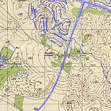
| Al-Kasayir خربة الكساير | |
|---|---|
 1870s map 1870s map
 1940s map 1940s map
 modern map modern map
 1940s with modern overlay map
A series of historical maps of the area around Khirbat Al-Kasayir (click the buttons) 1940s with modern overlay map
A series of historical maps of the area around Khirbat Al-Kasayir (click the buttons) | |
 | |
| Coordinates: 32°47′36″N 35°08′19″E / 32.79333°N 35.13861°E / 32.79333; 35.13861 | |
| Palestine grid | 163/244 |
| Geopolitical entity | Mandatory Palestine |
| Subdistrict | Haifa |
| Date of depopulation | mid-April, 1948 |
| Population | |
| • Total | 290 |
| Cause(s) of depopulation | Military assault by Yishuv forces |
Al-Kasayir (Arabic: خربة الكساير, Hebrew: ח'ירבת אל-קסאייר) was a Palestinian Arab village in the Haifa Subdistrict, located 13 km east of Haifa. It was depopulated during the 1947–48 Civil War in Mandatory Palestine on April 16, 1948, under the Battle of Mishmar HaEmek.
History
In the 1945 statistics Khirbat Al-Kasayir was counted among Shefa-'Amr suburbs, and it was noted with a population of 290 Muslims.
References
- Morris, 2004, p. xvii, village #383. Also gives cause of depopulation.
- Government of Palestine, Department of Statistics, 1945, p. 15
- Government of Palestine, Department of Statistics. Village Statistics, April, 1945. Quoted in Hadawi, 1970, p. 49
- Government of Palestine, Department of Statistics. Village Statistics, April, 1945. Quoted in Hadawi, 1970, p. 92
- Government of Palestine, Department of Statistics. Village Statistics, April, 1945. Quoted in Hadawi, 1970, p. 142
Bibliography
- Government of Palestine, Department of Statistics (1945). Village Statistics, April, 1945.
- Hadawi, S. (1970). Village Statistics of 1945: A Classification of Land and Area ownership in Palestine. Palestine Liberation Organization Research Center.
- Khalidi, W. (1992). All That Remains: The Palestinian Villages Occupied and Depopulated by Israel in 1948. Washington D.C.: Institute for Palestine Studies. ISBN 0-88728-224-5.
- Morris, B. (2004). The Birth of the Palestinian Refugee Problem Revisited. Cambridge University Press. ISBN 978-0-521-00967-6.
External links
- Welcome To al-Kasayir, Khirbat
- Khirbat al-Kasair, Zochrot
- Survey of Western Palestine, Map 5: IAA, Wikimedia commons
This geography of the State of Palestine article is a stub. You can help Misplaced Pages by expanding it. |
