| Korona Peak | |
|---|---|
| Pik Korona | |
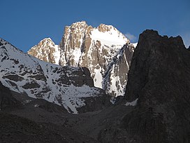
 Korona Peak viewed from Ratcek Hut to the northwest Korona Peak viewed from Ratcek Hut to the northwest | |
| Highest point | |
| Elevation | 4,860 m (15,940 ft) |
| Coordinates | 42°30′24″N 74°34′1″E / 42.50667°N 74.56694°E / 42.50667; 74.56694 |
| Geography | |
 | |
| Parent range | Kyrgyz Ala-Too Range, Tian Shan |
Korona Peak (Russian: пик Корона, romanized: Pik Korona, lit. 'Crown Peak') is a mountain in the Kyrgyz Ala-Too Range of the Tian Shan. It is located in Ala Archa National Park in Kyrgyzstan. It is named for its crown-like appearance.
Ak-Sai Glacier lies on its southwest flank.
References
This mountain, mountain range, or peak related article is a stub. You can help Misplaced Pages by expanding it. |