| Kuźnica | |
|---|---|
| Village | |
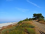
 Beach in Kuźnica Beach in Kuźnica | |
  | |
| Coordinates: 54°44′N 18°34′E / 54.733°N 18.567°E / 54.733; 18.567 | |
| Country | |
| Voivodeship | Pomeranian |
| County | Puck |
| Gmina | Jastarnia |
| First mentioned | 1570 |
| Time zone | UTC+1 (CET) |
| • Summer (DST) | UTC+2 (CEST) |
| Vehicle registration | GPU |
| Voivodeship roads | |
Kuźnica is a settlement and popular seaside resort in northern Poland, located between Chałupy and Jastarnia on the Hel Peninsula on the southern coast of the Baltic Sea in Puck County, Pomeranian Voivodeship.
History
The village was first mentioned in 1570. Kuźnica was a royal village of the Polish Crown, administratively located in the Puck County in the Pomeranian Voivodeship. In 1635, in the face of a Polish–Swedish War, Polish King Władysław IV Vasa ordered the construction of the Kazimierzowo sea fort. During the Swedish invasion of Poland (Deluge) in 1655 the Poles withdrew to Puck, and Kazimierzowo was taken over by the Swedes. After the war Kuźnica developed as a fishing village.
-
 Fisherman, before 1939
-
 Train in Hel, Kuźnica, before 1939
-
 Fishing nets, 1905–1944
-
 The sea between Kuźnica and Chałupy, before 1935
During the German occupation of Poland (World War II), several Poles from Hel were enslaved as forced labour to serve new German colonists in Kuźnica.
Gallery
See also
References
- ^ "Historia Kuźnicy". Kuznica.pl (in Polish). Retrieved 1 November 2020.
- Biskup, Marian; Tomczak, Andrzej (1955). Mapy województwa pomorskiego w drugiej połowie XVI w. (in Polish). Toruń. p. 100.
{{cite book}}: CS1 maint: location missing publisher (link) - Wardzyńska, Maria (2017). Wysiedlenia ludności polskiej z okupowanych ziem polskich włączonych do III Rzeszy w latach 1939-1945 (in Polish). Warsaw: IPN. p. 54. ISBN 978-83-8098-174-4.
External links
- Official website (in Polish)
This Puck County location article is a stub. You can help Misplaced Pages by expanding it. |


