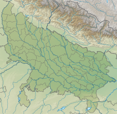
Lahuradewa (Lat. 26°46'12" N; Long. 82°56'59" E) is located in Sant Kabir Nagar District, in Sarayupar (Trans-Sarayu) region of the Upper Gangetic Plain in Uttar Pradesh state of India. The Sarayupar Plain is bounded by the Sarayu river in the west and south, Nepalese Terai in the north, and the Gandak River in the east.
The site is noted to have been occupied as early as 9,000 BCE, and by 7,000 BCE it provides the oldest evidence of ceramics in South Asia.
Excavations reported earliest archaeological sites in the world for cultivation of rice, with Lahuradewa Period IA giving samples that were dated by AMS radiocarbon to the 7th millennium BCE.
See also
References
- Colin Renfrew; Paul Bahn (9 June 2014). The Cambridge World Prehistory. Cambridge University Press. p. 1335. ISBN 9781107647756.
- Peter Bellwood; Immanuel Ness (10 November 2014). The Global Prehistory of Human Migration. John Wiley & Sons. p. 250. ISBN 9781118970591.
- Gwen Robbins Schug; Subhash R. Walimbe (13 April 2016). A Companion to South Asia in the Past. John Wiley & Sons. p. 350. ISBN 9781119055471.
- Early Farming at Lahuradewa; Rakesh Tewari, R.K. Srivastava, K.S. Saraswat, I.B. Singh, K.K. Singh Archived 12 July 2015 at the Wayback Machine
This Sant Kabir Nagar district location article is a stub. You can help Misplaced Pages by expanding it. |