Misplaced Pages

Lai-Hka

Article snapshot taken from[REDACTED] with creative commons attribution-sharealike license. Give it a read and then ask your questions in the chat. We can research this topic together.
"Laihka" redirects here. For the present-day administrative division, see Lai-Hka Township. For the former Shan princely state, see Laihka State. Town in Shan State, Myanmar
Lai-Hka ဝဵင်းလၢႆးၶႃႈလဲချားမြို့
Town
Lai-hka Shan State
Lai-Hka is located in MyanmarLai-HkaLai-HkaLocation in Burma
Coordinates: 21°16′20″N 97°39′10″E / 21.27222°N 97.65278°E / 21.27222; 97.65278
Country Myanmar
State Shan State
DistrictLai-Hka District
TownshipLai-Hka Township
Elevation3,116 m (10,223 ft)
Time zoneUTC+6.30 (MST)

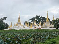
Lai-Hka (ဝဵင်းလၢႆးၶႃႈ) is a town of Lai-Hka District in the Shan State of Myanmar. It is the capital of Lai-Hka Township.

References

  1. Google Earth
Shan State
Capital: Taunggyi
East Shan State
Kengtung District
Mong Hpayak District
Mong Hsat District
Tachileik District

North Shan State
Kyaukme District
Lashio District
Laukkaing Districtsee Kokang Self-Administered Zone
Mu Se District
Hopang Districtsee Wa Self-Administered Division
Matman Districtsee Wa Self-Administered Division
Mongmit District
Kokang Self-Administered Zone
Pa Laung Self-Administered Zone
Wa Self-Administered Division
South Shan State
Langkho District
Loilen District
Taunggyi District
Danu Self-Administered Zone
Pa-O Self-Administered Zone
Main cities and towns
- also part of Kyaukme District; - also part of Hopang District; - also part of Matman District


Stub icon

This Shan State location article is a stub. You can help Misplaced Pages by expanding it.

Categories:
Lai-Hka Add topic