| This article includes a list of references, related reading, or external links, but its sources remain unclear because it lacks inline citations. Please help improve this article by introducing more precise citations. (March 2013) (Learn how and when to remove this message) |
| Anhalt-Zerbst | |
|---|---|
| District | |
 | |
| Country | Germany |
| State | Saxony-Anhalt |
| Disbanded | 2007-07-01 |
| Capital | Zerbst |
| Area | |
| • Total | 1,225 km (473 sq mi) |
| Population | |
| • Total | 79,500 |
| • Density | 65/km (170/sq mi) |
| Time zone | UTC+01:00 (CET) |
| • Summer (DST) | UTC+02:00 (CEST) |
| Vehicle registration | AZE |
| Website | http://www.anhalt-zerbst.de |
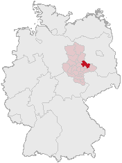
Anhalt-Zerbst was a district in Saxony-Anhalt, Germany. It is bounded by (from the north and clockwise) the districts Potsdam-Mittelmark (Brandenburg) and Wittenberg, the city of Dessau and the districts of Köthen, Schönebeck and Jerichower Land.
History
While Zerbst is a small town today, together with Dessau it was one of the two central cities of Anhalt. When the state of Anhalt was dissolved in 1603, one of the successor states was the principality of Anhalt-Zerbst. It was a small state with almost no political power. In 1793 the line of the princes became extinct, and Anhalt-Zerbst was annexed by the neighbouring principality of Anhalt-Dessau.
The present district was established in 1994 by merging the former districts of Zerbst and Roßlau with parts of the former district of Gräfenhainichen. Its borders are roughly identical with the ancient principality.
The district of Anhalt-Zerbst was dissolved in 2007 and divided into the new districts of Anhalt-Bitterfeld, Jerichower Land and Wittenberg.
Russian empress, Catherine the Great, was, by birth, a princess of Anhalt-Zerbst.
Geography
Anhalt-Zerbst comprises plain countryside north of the Elbe River. The Elbe enters the district in the east, runs through the southeastern part and then forms the southern and western border of Anhalt-Zerbst. The Elbe banks within the district are part of the Biosphere Reserve Middle Elbe. The north is occupied by the southern portions of the Fläming plateau.
Coat of arms

|
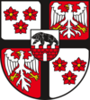
The coat of arms displays:
|
Towns and municipalities
| Towns | Verwaltungsgemeinschaften |
|---|---|
|
See also
External links
| Urban districts | |
|---|---|
| Rural districts | |
| Former districts | |
| Districts of German states (Full list) | |
| Cities and towns in the former district of Anhalt-Zerbst | ||
|---|---|---|
| ||
52°00′N 12°05′E / 52°N 12.08°E / 52; 12.08
Categories: