| Laroque-des-Albères | |
|---|---|
| Commune | |
 A general view of Laroque-des-Albères A general view of Laroque-des-Albères | |
 Coat of arms Coat of arms | |
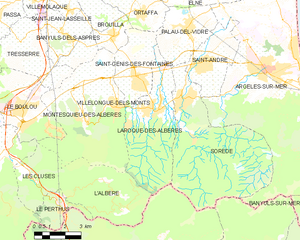
| Location of Laroque-des-Albères | |
  | |
| Coordinates: 42°31′26″N 2°55′58″E / 42.5239°N 2.9328°E / 42.5239; 2.9328 | |
| Country | France |
| Region | Occitania |
| Department | Pyrénées-Orientales |
| Arrondissement | Céret |
| Canton | Vallespir-Albères |
| Government | |
| • Mayor (2020–2026) | Christian Nauté |
| Area | 20.51 km (7.92 sq mi) |
| Population | 2,245 |
| • Density | 110/km (280/sq mi) |
| Time zone | UTC+01:00 (CET) |
| • Summer (DST) | UTC+02:00 (CEST) |
| INSEE/Postal code | 66093 /66740 |
| Elevation | 42–1,245 m (138–4,085 ft) (avg. 110 m or 360 ft) |
| French Land Register data, which excludes lakes, ponds, glaciers > 1 km (0.386 sq mi or 247 acres) and river estuaries. | |
Laroque-des-Albères (French pronunciation: [la ʁɔk de.z‿albɛʁ] ; Catalan: La Roca d'Albera) is a commune in the Pyrénées-Orientales department in southern France.
It is part of the Occitanie region. The town is in the foothills of the Pyrénées mountains.
Geography
Localisation
Laroque-des-Albères is located in the canton of Vallespir-Albères and in the arrondissement of Céret.

| Places adjacent to Laroque-des-Albères | ||||||||||||||||
|---|---|---|---|---|---|---|---|---|---|---|---|---|---|---|---|---|
| ||||||||||||||||
Government and politics
Mayors


| Mayor | Term start | Term end |
|---|---|---|
| François Olibo | 1792 | 1796 |
| Jean Poch | 1796 | 1800 |
| Joseph Gaspa | 1800 | 1802 |
| Joseph Pujas | 1802 | 8 June 1815 |
| François Vilar | 8 June 1815 | ? |
| Joseph Pujas | ? | 1816 |
| Joseph Malzach | 1816 | 1827 |
| Hyacinthe Carboneill | 1827 | 1830 |
| François Barate | 1830 | 1831 |
| Jacques Montoriol | 1831 | 1831 |
| Martin Fourcade | 1831 | 1834 |
| Blaise Roger | 1834 | 1837 |
| Jean Montoriol | 1837 | 1840 |
| Hyacinthe Carboneill | 1840 | 1841 |
| Jean Oursoul | 1841 | 1846 |
| Paul Vilar | 1846 | 1848 |
| Jean Chaubet | 1848 | 1848 |
| Pierre Vilar | 1848 | 1850 |
| Joseph Chaubet | 1850 | 1854 |
| Paul Vilar | 1854 | 1854 |
| Joseph Montoriol | 1854 | 1855 |
| Louis Malzach | 1855 | 1857 |
| Raymond Vassal | 1857 | 1860 |
| Jacques Cisque | 1860 | 1862 |
| Pierre Vilar | 1862 | 1869 |
| Louis Malzach | 1869 | 1970 |
| Théophile Vilar | 1870 | 1871 |
| Martin Durand | 1871 | 1874 |
| Joseph Malzach | 1874 | 1876 |
| Théophile Vilar | 1876 | 1876 |
| Joseph Molins | 1876 | 1879 |
| Joseph Cantuern | 1879 | 1881 |
| Jean Caurignac | 1881 | 1882 |
| Hyacinthe Oursol | 1882 | 1882 |
| Baptiste Pagès | 1882 | 1888 |
| Théophile Vilar | 1888 | 1893 |
| Pierre Vilar | 1893 | 1904 |
| Michel Bosch | 1904 | 1910 |
| Joseph Cantuern | 1910 | 1913 |
| Louis Solé | 1913 | 1928 |
| Joseph Carboneill | 1928 | 1941 |
| Étienne Courp | 1941 | 1944 |
| Louis Solé | 1944 | 1959 |
| François Domenjo | 1959 | 1965 |
| Fernand Soler | 1965 | 1983 |
| Sébastien Martinez | 1983 | 1989 |
| Pierre Romengas | 1989 | March 1995 |
| Maryse Armada | March 1995 | March 2008 |
| Jean-Pierre Bagate | March 2008 | September 2008 (resigned) |
| Christian Nauté | October 2008 |
Population
| Graphs are unavailable due to technical issues. Updates on reimplementing the Graph extension, which will be known as the Chart extension, can be found on Phabricator and on MediaWiki.org. |
| Year | Pop. | ±% p.a. |
|---|---|---|
| 1968 | 831 | — |
| 1975 | 984 | +2.44% |
| 1982 | 1,126 | +1.94% |
| 1990 | 1,508 | +3.72% |
| 1999 | 1,909 | +2.65% |
| 2007 | 1,968 | +0.38% |
| 2012 | 2,148 | +1.77% |
| 2017 | 2,112 | −0.34% |
| Source: INSEE | ||
Sites of interest
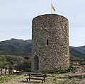
- The castle (12th century), one of the finest examples of incastellamento in the area.
- Puig Neulós
-
General view of the village
-
 The village seen from the castle
-
 The castle, 12th century (view southwest)
-
 The tower of the castle (view northwest)
-
The parish church
-
 Bell gable
-
 Portal with reliefs of St. Peter and St. Paul
-
 The chapel Notre-Dame de Tanya
-
Ruins of the chapel Saint-Fructueux de Roca-Vella
-
 The chapel Saint-Sébastien
See also
References
- "Répertoire national des élus: les maires". data.gouv.fr, Plateforme ouverte des données publiques françaises (in French). 2 December 2020.
- "Populations de référence 2022" (in French). The National Institute of Statistics and Economic Studies. 19 December 2024.
- INSEE commune file
- List from MairesGenWeb, except for François Vilar
- ^ Cardenas, Fabricio (21 February 2014). "Laroque-des-Albères, 8 juin 1815". Vieux papiers des Pyrénées-Orientales. Retrieved 20 February 2016.
- Population en historique depuis 1968, INSEE
This Pyrénées-Orientales geographical article is a stub. You can help Misplaced Pages by expanding it. |