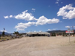
Unincorporated community in Nevada, United States
| Majors Place, Nevada | |
|---|---|
| Unincorporated community | |
 | |
| Etymology: Used to be known as Major Woods, named for the Major J. W. Woods, owner and operator. | |
 | |
| Coordinates: 39°01′30″N 114°34′55″W / 39.02500°N 114.58194°W / 39.02500; -114.58194 | |
| Country | United States |
| State | Nevada |
| County | White Pine |
| Elevation | 6,490 ft (1,980 m) |
| Time zone | UTC-8 (Pacific (PST)) |
| • Summer (DST) | UTC-7 (PDT) |
| GNIS feature ID | 860466 |
Majors Place is an unincorporated community in White Pine County, Nevada. It is at the junction of U.S. Route 6, U.S. Route 50 and U.S. Route 93. It includes a bar, restaurant, two hotel rooms, and an RV park. Fuel is no longer available.
In 1933, the location was known as Connors Station. In 1938, Majors Place was known as Conners Station.
Majors Station is east Connors Pass on U.S. Route 50. Connors Pass takes its name from Colonel P.E. Connors, who established Fort Ruby. The Conners variant name is said to take its name for a Mrs. Conners.
References
- "Pilot Forced Down In Spring Valley". Reno Evening Gazette. February 28, 1940. p. 12. Retrieved May 7, 2020.
- "Kimberly Man Facing Charge". Reno Evening Gazette. June 4, 1942. Retrieved May 7, 2020.
- ^ U.S. Geological Survey Geographic Names Information System: Majors Place, Nevada
- ^ Jensen, Jamie (2009). "Connors Pass and Major's Place". Loneliest Road: US-50. Avalon Travel. Retrieved June 24, 2013.
- Road Map of California Nevada Highways (Map). H. M. Gousha Company. 1938. Retrieved May 7, 2020.
- Federal Writers' Project (1940). Nevada: A Guide to the Silver State. Retrieved May 7, 2020.
- ^ Carlson, Helen S. (1985). Nevada Place Names: A Geographical Dictionary. University of Nevada Press. ISBN 978-0-87417-094-8. Retrieved May 7, 2020.
| Municipalities and communities of White Pine County, Nevada, United States | ||
|---|---|---|
| County seat: Ely | ||
| City |  | |
| CDPs | ||
| Other communities | ||
| Indian reservations | ||
| Ghost towns | ||
| Footnotes | ‡This populated place also has portions in an adjacent county or counties | |
This White Pine County, Nevada state location article is a stub. You can help Misplaced Pages by expanding it. |