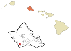
Census-designated place in Hawaii, United States
| Makakilo | |
|---|---|
| Census-designated place | |
 Makakilo Aerial Makakilo Aerial | |
 Location in Honolulu County and the state of Hawaii Location in Honolulu County and the state of Hawaii | |
| Coordinates: 21°21′10″N 158°5′27″W / 21.35278°N 158.09083°W / 21.35278; -158.09083 | |
| Country | United States |
| State | Hawaii |
| Counties | Honolulu |
| Area | |
| • Total | 3.82 sq mi (9.90 km) |
| • Land | 3.82 sq mi (9.90 km) |
| • Water | 0.00 sq mi (0.00 km) |
| Elevation | 600 ft (200 m) |
| Population | |
| • Total | 19,877 |
| • Density | 5,202.04/sq mi (2,008.73/km) |
| ZIP code | 96707 |
| Area code | 808 |
| FIPS code | 15-47600 |
Makakilo (Hawaiian pronunciation: [məkəˈtilo]) or Makakilo City is a census-designated place and residential area located in the ʻEwa District on the island of Oʻahu in the City & County of Honolulu, United States. In Hawaiian, maka kilo means "observing eyes". As of the 2020 census, the CDP had a population of 19,877.
Geography
Makakilo is located at 21°21′10″N 158°5′27″W / 21.35278°N 158.09083°W / 21.35278; -158.09083 (21.352850, -158.090732) on the southern end of the slopes of the Waiʻanae mountain range above the city of Kapolei. The Interstate H-1 freeway divides more recently developed Kapolei from Makakilo, and traveling eastward on H-1 connects to Waipahu. The freeway ends about 1.5 miles (2.4 km) west of Makakilo, merging into Farrington Highway (State Rte. 90) to Kahe Point and then Nānākuli on the Waiʻanae Coast. Exit 1 on H-1 is Kalaeloa Road, the entrance to Barbers Point and Campbell Industrial Park.
According to the United States Census Bureau, the CDP has a total area of 3.1 square miles (8.0 km), all land.
Demographics
| Census | Pop. | Note | %± |
|---|---|---|---|
| 2020 | 19,877 | — | |
| U.S. Decennial Census | |||
As of the census of 2000, there were 13,156 people, 3,898 households, and 3,223 families in the CDP. The population density was 4,188.0 inhabitants per square mile (1,617.0/km). There were 4,119 housing units at an average density of 1,311.2 per square mile (506.3/km). The racial makeup of the CDP was 24.16% White, 2.53% Black or African American, 0.20% Native American, 32.08% Asian, 10.20% Pacific Islander, 1.51% from other races, and 29.32% from two or more races. 10.09% of the population were Hispanic or Latino of any race.
Of the 3,898 households 44.2% had children under the age of 18 living with them, 65.9% were married couples living together, 11.3% had a female householder with no husband present, and 17.3% were non-families. 11.3% of households were one person and 1.4% were one person aged 65 or older. The average household size was 3.37 and the average family size was 3.64.
The age distribution was 30.5% under the age of 18, 8.4% from 18 to 24, 33.6% from 25 to 44, 21.5% from 45 to 64, and 6.1% 65 or older. The median age was 32 years. For every 100 females, there were 101.0 males. For every 100 females age 18 and over, there were 98.5 males.
The median household income was $66,515 and the median family income was $67,267. Males had a median income of $40,067 versus $31,194 for females. The per capita income for the CDP was $20,945. 5.1% of the population and 4.3% of families were below the poverty line. Out of the total population, 7.1% of those under the age of 18 and 3.6% of those 65 and older were living below the poverty line.
Education
Hawaii Department of Education operates two public elementary schools in the CDP: Makakilo Elementary School and Mauka Lani Elementary School.
Recreation
Wet'n'Wild Hawaii was defined in the Makakilo City CDP in the 2000 U.S. Census but for the 2010 U.S. Census was redefined as being in Kapolei CDP.
References
- "2020 U.S. Gazetteer Files". United States Census Bureau. Retrieved December 18, 2021.
- "Makakilo ZIP Code". zipdatamaps.com. 2023. Retrieved January 12, 2023.
- "US Gazetteer files: 2010, 2000, and 1990". United States Census Bureau. February 12, 2011. Retrieved April 23, 2011.
- "Census of Population and Housing". Census.gov. Retrieved June 4, 2016.
- ^ "2010 CENSUS - CENSUS BLOCK MAP: Makakilo CDP, HI" (PDF). U.S. Census Bureau. Retrieved October 10, 2020.
- "CENSUS 2000 BLOCK MAP: MAKAKILO CITY CDP" (PDF). U.S. Census Bureau. Retrieved October 10, 2020.
- "Home". Makakilo Elementary School. Retrieved October 10, 2020.
92-675 Anipeahi Street, Kapolei, HI 96707
- "Home". Mauka Lani Elementary School. Retrieved October 10, 2020.
92-1300 Panana Street, Kapolei, HI 96707
- "2010 CENSUS - CENSUS BLOCK MAP: Kapolei CDP, HI" (PDF). U.S. Census Bureau. Retrieved October 10, 2020. - Compare this map to addresses of schools to see which ones are in the CDP.
- "Home". Wet'n'Wild Hawaii. Retrieved October 10, 2020.
400 Farrington Hwy Kapolei, HI 96707
| Islands, municipalities, and communities of Honolulu County, Hawaii, United States | |||||
|---|---|---|---|---|---|
| County seat: Honolulu | |||||
| CDPs |
|  | |||
| Other communities | |||||
| Government |
| ||||