Unincorporated community in Hawaii, United States
| Makanalua, Hawaii | |
|---|---|
| Unincorporated community | |
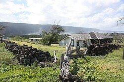
 Lighthouse keepers' residence Lighthouse keepers' residence | |
 | |
| Coordinates: 21°11′33″N 156°58′19″W / 21.19250°N 156.97194°W / 21.19250; -156.97194 | |
| Country | United States |
| State | Hawaii |
| County | Kalawao |
| Area | |
| • Land | 3.229 sq mi (8.363 km) |
| Elevation | 128 ft (39 m) |
| Population | |
| • Total | 8 |
| Time zone | UTC-10 (Hawaii-Aleutian) |
| Area code | 808 |
| GNIS feature ID | 362068 |
Makanalua (also Makanaloa) is an unincorporated community and ahupuaʻa in Kalawao County, Hawaii, United States. During the Great Māhele of 1848, the land was retained for Princess Kekauʻōnohi. The name means "double gift" in the Hawaiian language.
Notes
- ^ "Makanalua, Hawaii". Geographic Names Information System. United States Geological Survey, United States Department of the Interior.
- Lloyd J. Soehren (2010). "lookup of Salt Lake". in Hawaiian Place Names. Ulukau, the Hawaiian Electronic Library. Retrieved September 24, 2010.
- Pukui, Mary Kawena; Elbert, Samuel H.; Mookini, Esther T. (1974). Place Names of Hawaii. Honolulu: University of Hawaii Press. p. 141. ISBN 978-0-8248-0524-1. OCLC 1042464.
| Islands, municipalities, and communities of Kalawao County, Hawaii, United States | ||
|---|---|---|
| Unincorporated communities |  | |
| Ghost Towns | ||
| Footnotes | ‡This populated place also has portions in an adjacent county or counties | |
This Hawaiʻi state location article is a stub. You can help Misplaced Pages by expanding it. |