| This article is an orphan, as no other articles link to it. Please introduce links to this page from related articles; try the Find link tool for suggestions. (August 2024) |
| Meka'ika ሜካኢካ | |
|---|---|
| Unincorporated Community | |
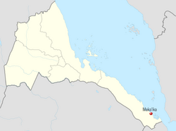
 Location of Meka'ika, Eritrea Location of Meka'ika, Eritrea | |
| Coordinates: 13°03′26″N 42°40′01″E / 13.05722°N 42.66694°E / 13.05722; 42.66694 | |
| Country | |
| Region | Southern Red Sea |
| District | Southern Denkalya |
| Elevation | 6 m (20 ft) |
Meka'ika (Tigrinya: ሜካኢካ) is a small coastal town in the Southern Denkalya subregion, Southern Red Sea region in Eritrea.
Meka'ika is located on the Massawa–Assab highway (P-6), immediately south of the Assab International Airport and approximately 10 km (6.2 mi) north-west of Assab and 476 km (296 mi) south-east of Asmara, the country's capital. The town borders the Red Sea, with the islands of Fatma and Halib close by.
References
- Woldemikael, Tekle Mariam (January 1, 2018), "Introduction: Postliberation Eritrea", Postliberation Eritrea, Indiana University Press, retrieved September 13, 2021
- Gazetteer of Ethiopia: Names Approved by the United States Board on Geographic Names. Defense Mapping Agency. 1982. p. 477.
- "ASSAB". Encyclopédie de l’Islam. Retrieved September 12, 2021.
- "Meka'ika - Eritrea". IndexMundi. Retrieved September 13, 2021.