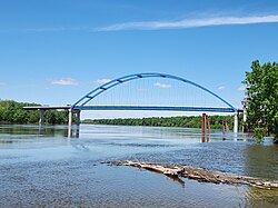
Bridge in Meredosia, Illinois
| Meredosia Bridge | |
|---|---|
 | |
| Coordinates | 39°49′51″N 90°33′57″W / 39.83073°N 90.56580°W / 39.83073; -90.56580 |
| Carries | |
| Crosses | Illinois River |
| Locale | Meredosia, Illinois |
| Maintained by | Illinois DOT |
| ID number | 000069001615775 |
| Characteristics | |
| Design | Tied arch |
| Total length | 2,232 feet (0.4227 mi; 0.680 km) |
| Clearance below | 72 feet (22 m) |
| History | |
| Constructed by | Halverson Construction |
| Construction start | 2015 |
| Construction end | 2018 |
| Construction cost | $86.2 million |
| Opened | 2018 (2018) |
| Inaugurated | June 19, 2018 |
| Statistics | |
| Daily traffic | 2,400 (2005) |
| Location | |
The Meredosia Bridge is a two-lane tied-arch bridge constructed in 2018 that carries Illinois Route 104 (IL 104) across the Illinois River between Pike County, Illinois and the city of Meredosia, Morgan County, Illinois. The current bridge was built 250 feet (76 m) north of the old steel truss bridge.
See also
References
- ^ "Meredosia Bridge". Bridgehunter.com: Historic Bridges of the United States. James Baughn. Retrieved February 26, 2017.
- Blanchette, David (February 14, 2017). "Meet-in-the-middle bridge construction underway at Meredosia". The State Journal-Register. Retrieved January 10, 2018.
External links
| Crossings of the Illinois River | ||||
|---|---|---|---|---|
| ||||
This article about a bridge in Illinois is a stub. You can help Misplaced Pages by expanding it. |