| This article does not cite any sources. Please help improve this article by adding citations to reliable sources. Unsourced material may be challenged and removed. Find sources: "Mistaya Canyon" – news · newspapers · books · scholar · JSTOR (December 2009) (Learn how and when to remove this message) |
| This article may need to be rewritten to comply with Misplaced Pages's quality standards. You can help. The talk page may contain suggestions. (June 2022) |

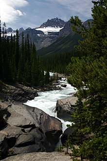
Mistaya Canyon is a canyon in the western part of the Canadian province of Alberta. It is formed by the Mistaya River. Tourists who are visiting Banff National Park often visit it because of its distinctive curvy canyon walls and because it is easy to access, being just off the Icefields Parkway. The 0.5 km trail to the canyon is located at a large parking area on the west side of the Parkway, part way up the long hill south of the North Saskatchewan River. There are actually two such parking areas on the hill; the Mistaya one is clearly marked by signs on the highway and at the beginning of the trail. The trail is an easy walk in summer but too steep for wheelchairs. The canyon is deep and there are no railings. The trail is icy in early spring.
Hikers will find that the Howse Pass Trail continues past the canyon. 51°57′01″N 116°43′00″W / 51.95028°N 116.71667°W / 51.95028; -116.71667 (Mistaya Canyon)
This Alberta's Rockies location article is a stub. You can help Misplaced Pages by expanding it. |