| Mount Flat Top | |
|---|---|
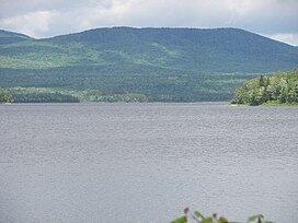
 View from Flat Top Mountain at the lac aux Araignées access point on route 161. View from Flat Top Mountain at the lac aux Araignées access point on route 161. | |
| Highest point | |
| Peak | 830 metres (2,720 ft) |
| Parent peak | White Mountains (Appalachian Mountains) |
| Coordinates | 45°29′07″N 70°43′42″W / 45.48528°N 70.72833°W / 45.48528; -70.72833 |
| Geography | |
| Location | Estrie |
| Country | Canada |
| Province | Québec |
| Region | Region |
The Mount Flat Top is a mountain in administrative region of Estrie, in Quebec, Canada. It is part of the Appalachian Mountains; its altitude is 830 meters.
Geography
The mountain is located in the municipality of Frontenac, in zec Louise-Gosford, east of lac aux Araignées, between Merrill Mountain and Moose Hill. It overlooks the rivière aux Araignées, as well as the lac aux Araignées.
Toponymy
The toponym "Mont Flat Top" was formalized on December 5, 1968 by the Commission de toponymie du Québec.
Notes and references
- Mont Flat Top, Commission de toponymie du Québec.
- "Descriptive file: Mont Flat Top". www.toponymie.gouv.qc.ca. Retrieved 2021-01-06.
This article related to a mountain, mountain range, or peak in Canada is a stub. You can help Misplaced Pages by expanding it. |
This Quebec location article is a stub. You can help Misplaced Pages by expanding it. |