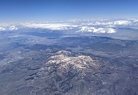
| Mount Patterson | |
|---|---|
 Mount Patterson from the southwest Mount Patterson from the southwest | |
| Highest point | |
| Elevation | 11,654 feet (3,552 m) |
| Prominence | 4,193 ft (1,278 m) |
| Coordinates | 38°26′12″N 119°18′19″W / 38.43667°N 119.30528°W / 38.43667; -119.30528 |
| Geography | |
 | |
| Parent range | Sweetwater Mountains |
| Geology | |
| Rock age | Uncertain |
| Mountain type | Rhyolitic volcano |
| Volcanic arc | Sweetwater Mountains, Sierra Nevada |
Mount Patterson is a mountain peak located in Mono County, California.
The summit is 11,654 feet (3,552 m) in elevation making it the highest mountain in the Sweetwater Mountains.
Climate
There is no weather station at the summit, but this climate table contains interpolated data for an area around the summit. The peak of Mount Patterson has an Alpine climate (ET).
| Climate data for Mount Patterson 38.4189 N, 119.2930 W, Elevation: 11,411 ft (3,478 m) (1991–2020 normals) | |||||||||||||
|---|---|---|---|---|---|---|---|---|---|---|---|---|---|
| Month | Jan | Feb | Mar | Apr | May | Jun | Jul | Aug | Sep | Oct | Nov | Dec | Year |
| Mean daily maximum °F (°C) | 30.5 (−0.8) |
29.2 (−1.6) |
31.6 (−0.2) |
36.0 (2.2) |
44.1 (6.7) |
54.3 (12.4) |
62.9 (17.2) |
62.3 (16.8) |
56.2 (13.4) |
46.7 (8.2) |
36.4 (2.4) |
30.4 (−0.9) |
43.4 (6.3) |
| Daily mean °F (°C) | 21.4 (−5.9) |
19.4 (−7.0) |
21.4 (−5.9) |
24.6 (−4.1) |
32.0 (0.0) |
41.3 (5.2) |
49.1 (9.5) |
48.4 (9.1) |
42.7 (5.9) |
34.6 (1.4) |
26.7 (−2.9) |
21.4 (−5.9) |
31.9 (0.0) |
| Mean daily minimum °F (°C) | 12.2 (−11.0) |
9.6 (−12.4) |
11.3 (−11.5) |
13.2 (−10.4) |
20.0 (−6.7) |
28.2 (−2.1) |
35.3 (1.8) |
34.5 (1.4) |
29.3 (−1.5) |
22.5 (−5.3) |
17.0 (−8.3) |
12.4 (−10.9) |
20.5 (−6.4) |
| Average precipitation inches (mm) | 8.88 (226) |
7.43 (189) |
6.50 (165) |
3.53 (90) |
2.12 (54) |
0.66 (17) |
0.71 (18) |
0.72 (18) |
0.59 (15) |
2.25 (57) |
3.27 (83) |
7.27 (185) |
43.93 (1,117) |
| Source: PRISM Climate Group | |||||||||||||
See also
References
- ^ "Mount Patterson, California". Peakbagger.com. Retrieved October 1, 2020.
- ^ "Mount Patterson". Geographic Names Information System. United States Geological Survey, United States Department of the Interior. Retrieved October 1, 2020.
- "PRISM Climate Group, Oregon State University". PRISM Climate Group, Oregon State University. Retrieved October 6, 2023.
To find the table data on the PRISM website, start by clicking Coordinates (under Location); copy Latitude and Longitude figures from top of table; click Zoom to location; click Precipitation, Minimum temp, Mean temp, Maximum temp; click 30-year normals, 1991-2020; click 800m; click Retrieve Time Series button.