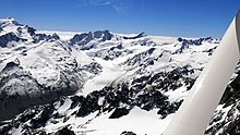
The Murchison Glacier is an 18-kilometre (11 mi) long glacier flowing through Aoraki / Mount Cook National Park in the South Island of New Zealand. Lying to the east of the Malte Brun range and west of the Liebig Range, high in the Southern Alps, it flows from the Tasman Saddle at 2,435 m mostly southwestwards to around 1,110 m. The Murchison River, which takes its meltwater, flows under the larger Tasman Glacier to the south.
The Murchison Glacier is named after Roderick Murchison, one of the founders of the Royal Geographical Society.
See also
References
- Grove, Jean M. (2004). Little Ice Ages: Ancient and Modern. Taylor & Francis. p. 352. ISBN 0-415-33422-5.
- Reed, A. W. (2010). Peter Dowling (ed.). Place Names of New Zealand. Rosedale, North Shore: Raupo. p. 263. ISBN 9780143204107.
| Aoraki / Mount Cook National Park, New Zealand | |
|---|---|
| Mountains | |
| Mountain ranges | |
| Glaciers | |
| Lakes | |
| Rivers | |
| Other geographic features | |
| Settlements and buildings | |
| Walking and cycling tracks | |
| Reserves and World Heritage Sites | |
43°35′S 170°22′E / 43.583°S 170.367°E / -43.583; 170.367
This Canterbury Region-related geography article is a stub. You can help Misplaced Pages by expanding it. |