Protected area in New South Wales, Australia
| Ngambaa Nature Reserve New South Wales | |
|---|---|
| IUCN category II (national park) | |
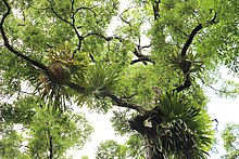
 red cedar & epiphytes red cedar & epiphytes | |
 | |
| Nearest town or city | Macksville |
| Coordinates | 30°52′48″S 152°46′54″E / 30.88000°S 152.78167°E / -30.88000; 152.78167 |
| Established | 1 January 1999 (1999-01-01) |
| Area | 10,560 hectares |
| Managing authorities | NSW National Parks and Wildlife Service |
| Website | Ngambaa Nature Reserve |
| See also | Protected areas of New South Wales |
Ngambaa Nature Reserve, including Red Cedar Park is a protected area of 10,560 hectares, situated in the Mid North Coast region of New South Wales. The nearest large town is Macksville. The reserve endeavours to protect many rare and threatened flora and fauna species, such as rainforest and four species of ironbark trees. An interesting local species is the small bolwarra, one of the most primitive of flowering plants. The landscapes are of significance to the local Aboriginal communities, and contain relics of historical use by non-Aboriginal people.
One of the inhabitants of the park is the powerful owl, Australia's largest owl. One pair can hunt on an area of 1000 hectares, so it is difficult to spot them. Their main food is possums and sugar gliders.
The reserve is located at 139 meters above sea level.
See also
References
- "Ngambaa". Protected Planet. Retrieved 30 December 2018.
- New South Wales National Parks & Wildlife Service. "Ngambaa Nature Reserve". Retrieved 27 April 2018.
- Macleay Valley Coast - Great things to do. "Ngambaa Nature Reserve". Retrieved 27 April 2018.
- NSW National Parks and Wildlife Service. Part of the Department of Environment and Conservation (NSW). "Plan of Management - Ngambaa Nature Reserve". Retrieved 27 April 2018.
- "Ngambaa Nature Reserve | Learn more". NSW National Parks. Retrieved 23 November 2021.
- "Ngambaa Nature Reserve NSW". ExplorOz. Retrieved 24 November 2021.
| Nature reserves of New South Wales, Australia | |
|---|---|
| Central West & Orana |
|
| Far West |
|
| Hunter & Central Coast |
|
| Illawarra-Shoalhaven |
|
| New England-North West |
|
| North Coast |
|
| Riverina-Murray |
|
| Southeast & Tablelands |
|
| Sydney & Surrounds |
|
| Protected areas of New South Wales | |
This New South Wales protected areas related article is a stub. You can help Misplaced Pages by expanding it. |