Map all coordinates using OpenStreetMap
Download coordinates as:
Suburb of Scenic Rim Region, Queensland, Australia| O'Reilly Queensland | |||||||||||||||
|---|---|---|---|---|---|---|---|---|---|---|---|---|---|---|---|
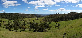
 Mountain scenery, 2013 Mountain scenery, 2013 | |||||||||||||||
 | |||||||||||||||
| Coordinates | 28°12′36″S 153°07′38″E / 28.2100°S 153.1272°E / -28.2100; 153.1272 (O'Reilly (centre of locality)) | ||||||||||||||
| Population | 114 (2021 census) | ||||||||||||||
| • Density | 1.547/km (4.006/sq mi) | ||||||||||||||
| Postcode(s) | 4275 | ||||||||||||||
| Area | 73.7 km (28.5 sq mi) | ||||||||||||||
| Time zone | AEST (UTC+10:00) | ||||||||||||||
| Location |
| ||||||||||||||
| LGA(s) | Scenic Rim Region | ||||||||||||||
| State electorate(s) | Scenic Rim | ||||||||||||||
| Federal division(s) | Wright | ||||||||||||||
| |||||||||||||||
O'Reilly is a rural locality in the Scenic Rim Region, Queensland, Australia. It borders New South Wales. In the 2021 census, O'Reilly had a population of 114 people.
Geography
O'Reilly is located on Queensland's border with New South Wales on the elevated Lamington Plateau. The plateau remains heavily vegetated by Gondwana Rainforests.
Almost the whole of the locality is within the Lamington National Park, except for the Boonyong pastoral property (28°13′06″S 153°06′59″E / 28.2183°S 153.1165°E / -28.2183; 153.1165 (Booyong pastoral property)) and the O'Reilly's Rainforest Retreat mountain resort (28°13′50″S 153°07′49″E / 28.2305°S 153.1304°E / -28.2305; 153.1304 (O'Reilly's Rainforest Retreat)).
The Lamington National Park contains a network of walking tracks, lookouts and numerous waterfalls.
Demographics
In the 2016 census, O'Reilly had "no people or a very low population".
In the 2021 census, O'Reilly had a population of 114 people.
Education
There are no schools in O'Reilly. The nearest primary school is Canungra State School in Canungra. The nearest secondary school is Tamborine Mountain State High School in Tamborine Mountain.
References
- ^ Australian Bureau of Statistics (28 June 2022). "O'Reilly (SAL)". 2021 Census QuickStats. Retrieved 28 February 2023.

- "O'Reilly – locality in Scenic Rim Region (entry 45177)". Queensland Place Names. Queensland Government. Retrieved 27 January 2020.
- ^ "Queensland Globe". State of Queensland. Retrieved 3 May 2020.
- "Lamington National Park". Department of Environment and Science. Queensland Government. 19 October 2009. Archived from the original on 4 May 2020. Retrieved 4 May 2020.
- Australian Bureau of Statistics (27 June 2017). "O'Reilly (SSC)". 2016 Census QuickStats. Retrieved 20 October 2018.
