| This article needs additional citations for verification. Please help improve this article by adding citations to reliable sources. Unsourced material may be challenged and removed. Find sources: "Oderwald" – news · newspapers · books · scholar · JSTOR (September 2021) (Learn how and when to remove this message) |
| Oderwald | |
|---|---|
| Samtgemeinde | |
 Coat of arms Coat of arms | |
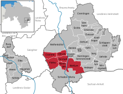
Location of Oderwald within Wolfenbüttel district
 | |
  | |
| Coordinates: 52°04′N 10°35′E / 52.067°N 10.583°E / 52.067; 10.583 | |
| Country | Germany |
| State | Lower Saxony |
| District | Wolfenbüttel |
| Subdivisions | 6 municipalities |
| Area | |
| • Total | 89.04 km (34.38 sq mi) |
| Population | |
| • Total | 6,758 |
| • Density | 76/km (200/sq mi) |
| Time zone | UTC+01:00 (CET) |
| • Summer (DST) | UTC+02:00 (CEST) |
| Vehicle registration | WF |
| Website | www |
Oderwald is a Samtgemeinde ("collective municipality") in the district of Wolfenbüttel, in Lower Saxony, Germany. It is situated along the river Oker, approx. 10 km south of Wolfenbüttel. It is named after the Oderwald, a small chain of hills in the municipality. Its seat is in the village Börßum.
The Samtgemeinde Oderwald consists of the following municipalities:
References
- "LSN-Online Regionaldatenbank, Tabelle A100001G: Fortschreibung des Bevölkerungsstandes, Stand 31. Dezember 2022" (in German). Landesamt für Statistik Niedersachsen.
This Wolfenbüttel district location article is a stub. You can help Misplaced Pages by expanding it. |