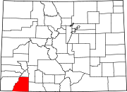
Oxford is an unincorporated community in on the Southern Ute Indian Reservation in La Plata County, Colorado, United States.
History
The townsite map was recorded November 3, 1909 by The Oxford Land and Townsite Co. alongside the Denver & Rio Grande RR by J.M. Denning. A post office called Oxford was established in 1908, and remained in operation until 1954. The name Oxford was selected on account of its euphonic sound, according to local history.
See also
References
- U.S. Geological Survey Geographic Names Information System: Oxford
- "Post offices". Jim Forte Postal History. Retrieved July 6, 2016.
- Dawson, John Frank. Place names in Colorado: why 700 communities were so named, 150 of Spanish or Indian origin. Denver, CO: The J. Frank Dawson Publishing Co. p. 39.
External links
[REDACTED] Media related to Oxford, Colorado at Wikimedia Commons
| Municipalities and communities of La Plata County, Colorado, United States | ||
|---|---|---|
| County seat: Durango | ||
| City |  | |
| Towns | ||
| CDPs | ||
| Unincorporated communities | ||
| Ghost towns | ||
| Indian reservations | ||
| Footnotes | ‡This populated place also has portions in an adjacent county or counties | |
37°10′08″N 107°42′51″W / 37.16889°N 107.71417°W / 37.16889; -107.71417
This Colorado state location article is a stub. You can help Misplaced Pages by expanding it. |