You can help expand this article with text translated from the corresponding article in German. (October 2024) Click for important translation instructions.
|
| Parchamo | |
|---|---|
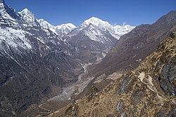
 Parchamo is the snow-capped lower mountain on the left of the center of the picture Parchamo is the snow-capped lower mountain on the left of the center of the picture | |
| Highest point | |
| Elevation | 6,187 m (20,299 ft) |
| Coordinates | 27°50′11.66″N 86°32′50.78″E / 27.8365722°N 86.5474389°E / 27.8365722; 86.5474389 |
| Geography | |
 | |
| Location | Rolwaling Himal, Nepal |
| Parent range | Rolwaling Himal |
| Climbing | |
| First ascent | 18 April 1955 by Phil Boultbee und Dennis Davis |
| Easiest route | snow/ice climb |
Parchamo (also Pharchamo, Parchemuche, Parchoma, Pachermo Peak or Pachhermo Peak) is a 6,187 metres (20,299 ft) high trekking peak in the Rolwaling Himal mountain range of the Himalayas. It is located on the boundary between the Dolakha District and the Solukhumbu District of Nepal.
The summit offers a view of Mount Everest, Cho Oyu and Gyachung Kang with good visibility. On the north flank of Parchamo is the 5,755 metres (18,881 ft) high Tashi Lapcha (Tesi Lapcha) pass, which leads from the Drolambao glacier in the west to the mountain village of Namche Bazaar in the east. North of the Tashi Lapcha pass rises the 6,943 metres (22,779 ft) high Tengi Ragi Tau. To the south, a ridge leads from Parchamo to the 6,718 metres (22,041 ft) Likhu Chuli.
The first ascent of Parchamo was made by a UK expedition led by Alfred Gregory in 1955, Phil Boultbee and Dennis Davis reached the summit on 18 April 1955.
References
- "Parchamo Peak, Nepal". peakbagger.com. Retrieved 2024-10-09.
- ^ O’Connor, Bill (1992). The Trekking Peaks of Nepal. Crowood. ISBN 9781852236519.
- "The Merseyside Himalayan Expedition". MEF – Mount Everest Foundation. Retrieved 9 October 2024.
- Gregory, Alfred (1956). "The Merseyside Himalayan Expedition 1955" (PDF). Alpine Journal. #61: 54–59. ISSN 0065-6569. Retrieved 9 October 2024.
This article related to a mountain or hill in Nepal is a stub. You can help Misplaced Pages by expanding it. |