| Pine Dock Airport | |||||||||||
|---|---|---|---|---|---|---|---|---|---|---|---|
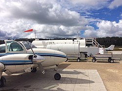
 Pine Dock fuel tanks and aircraft Pine Dock fuel tanks and aircraft | |||||||||||
| Summary | |||||||||||
| Airport type | Public | ||||||||||
| Operator | Lakeside/Interlake Aviation | ||||||||||
| Location | Pine Dock, Manitoba | ||||||||||
| Time zone | CST (UTC−06:00) | ||||||||||
| • Summer (DST) | CDT (UTC−05:00) | ||||||||||
| Elevation AMSL | 749 ft / 228 m | ||||||||||
| Coordinates | 51°37′10″N 096°48′44″W / 51.61944°N 96.81222°W / 51.61944; -96.81222 | ||||||||||
| Map | |||||||||||
  | |||||||||||
| Runways | |||||||||||
| |||||||||||
| Sources: Canada Flight Supplement | |||||||||||
Pine Dock Airport (TC LID: CKQ9) is located 1 nautical mile (1.9 km; 1.2 mi) south of Pine Dock, Manitoba, Canada.
Pine Dock Airport is a public airport owned by Interlake Aviation / Lakeside Aviation. This aircraft charter company services the Lake Winnipeg region which includes areas such as Berens River, Poplar River, Bloodvein River, and St. Theresa Point. Lakeside Aviation has an airport terminal and fuel tanks for jet and avgas (100LL) aviation fuel, and bases charter aircraft like its Cessna 206 aircraft there.

See also
References
- Canada Flight Supplement. Effective 0901Z 16 July 2020 to 0901Z 10 September 2020.
External links
Portals:| Airports in Canada | |
|---|---|
| By name | |
| By location indicator | |
| By province/territory | |
| By area | |
| National Airports System | |
| Related | |
This article about an airport in Manitoba is a stub. You can help Misplaced Pages by expanding it. |