| Mesa Prieta | |
|---|---|
| Mesa | |
 | |
 | |
| Coordinates: 35°28′26″N 107°03′12″W / 35.473951°N 107.053356°W / 35.473951; -107.053356 | |
| Location | 25 km west of San Ysidro, NM |
| Formed by | basaltic lava flow during the Pliocene |
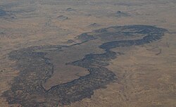
Mesa Prieta is a mesa in Sandoval County New Mexico. The mesa was formed by a basaltic lava flow during the Pliocene. The sedimentary rocks include the Cretaceous Dakota Sandstone, Mancos Shale, and Gallup Sandstone.
The Rio Puerco flows south on the west side of the mesa. The Ojito Wilderness is to the east of the mesa, and Cabezon Peak is to the north.
References
- Dillinger, J. K., 1990. Geologic map of the Grants 30' x 60' quadrangle, west-central New Mexico, U.S. Geological Survey, Coal Investigations Map C-118-A. Map Scale: 1:100,000.
| Municipalities and communities of Sandoval County, New Mexico, United States | ||
|---|---|---|
| County seat: Bernalillo | ||
| City |  | |
| Towns | ||
| Villages | ||
| CDPs | ||
| Unincorporated community | ||
| Indian reservations | ||
| Footnotes | ‡This populated place also has portions in an adjacent county or counties | |