You can help expand this article with text translated from the corresponding article in Dutch. Click for important translation instructions.
|
 Provincial highway 307
 | |
|---|---|
| Provinciale weg 307 | |
 | |
| Route information | |
| Length | 35.2 km (21.9 mi) |
| Major junctions | |
| West end | |
| Major intersections | |
| East end | |
| Location | |
| Country | Kingdom of the Netherlands |
| Constituent country | Netherlands |
| Provinces | Flevoland, Overijssel |
| Municipalities | Lelystad, Dronten, Kampen |
| Highway system | |
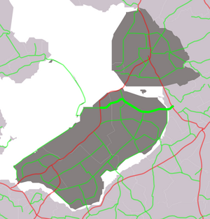
Provincial road N307 (N307) is a road connecting Rijksweg 6 (A6) and N302 near Lelystad with Rijksweg 50 (N50) in Kampen.
Exit list
| Province | Municipality | km | mi | Destinations | Notes |
|---|---|---|---|---|---|
| Flevoland | Lelystad | 8.9 | 5.5 | ||
| Dronten | 15.6 | 9.7 | |||
| 20.1– 20.6 | 12.5– 12.8 | ||||
| 23.8 | 14.8 | ||||
| 27.3 | 17.0 | Ketelweg | |||
| 29.2 | 18.1 | Roggebotweg | |||
| 31.9 | 19.8 | ||||
| Vossemeer / Drontermeer | 32.0 | 19.9 | Roggebot sluice | ||
| Overijssel | Kampen | 32.2– 33.0 | 20.0– 20.5 | Flevoweg / Reeveweg | |
| 33.9 | 21.1 | Buitendijksweg | |||
| 34.5 | 21.4 | Schansdijk / Flevoweg | |||
| 34.9 | 21.7 | ||||
| 35.2 | 21.9 | Zambonistraat / Flevoweg | |||
| 1.000 mi = 1.609 km; 1.000 km = 0.621 mi | |||||
References
- "Gemeenteatlas" [Municipality atlas] (in Dutch). Imergis. June 16, 2018. Retrieved September 4, 2018.
- "imkaart". Stichting Incident Management Nederland. Retrieved September 4, 2018.
