| Punta Petrona Natural Reserve | |
|---|---|
| Reserva Natural Punta Petrona | |
| IUCN category V (protected landscape/seascape) | |
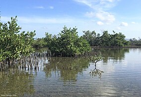
 Punta Petrona Natural Reserve (2022) Punta Petrona Natural Reserve (2022) | |
 | |
| Location | Santa Isabel, Puerto Rico |
| Coordinates | 17°56′20″N 66°23′02″W / 17.939°N 66.384°W / 17.939; -66.384 |
Punta Petrona is a cape and protected area located in southern Puerto Rico, in the Felicia 1 district (Spanish: barrio) of the municipality of Santa Isabel. Located in the Caribbean Sea coast, it is bordered by the Rincón Bay to the east, and the bight of Caja de Muertos to the west. Punta Petrona contains a mangrove forest and it is surrounded by small cays, namely the Cayos Caracoles ('shell cays'), Cayos Cabezazos ('head cays') and Cayo Alfeñique ('weak cay'), which serve as a habitats for the West Indian manatee. It is also an important coral reef area frequented by sea turtles. The area is protected as the Punta Petrona Natural Reserve, part of the wider Aguirre State Forest; however, the Puerto Rican Planning Society (Sociedad Puertorriqueña de Planificación) revealed in 2018 that this nature reserve did not have the proper state management and classification regulations.
Punta Petrona can be accessed by private boat from nearby Jauca and El Malecón areas of Santa Isabel.
See also
References
- "Bahía de Rincón bay, Santa Isabel Municipio, Puerto Rico". pr.geoview.info. Archived from the original on 2022-02-13. Retrieved 2022-02-12.
- Florida FWC - Fish and Wildlife Research Institute (May 27, 2011). "Geographic Response Plan Map: PR-61" (PDF). ocean.floridamarine.org.
- North Carolina State University, North Carolina Agricultural Research Service, College of Agriculture and Life Sciences (2012). "Science Summary in Support of Manatee Protection Area (MPA) Design in Puerto Rico" (PDF). Archived (PDF) from the original on 2022-02-13.
{{cite web}}: CS1 maint: multiple names: authors list (link) - National Oceanic and Atmospheric Administration, NOAA’s National Ocean Service Management & Budget Office (February 2009). "Coral Reef Habitat Assessment for U.S. Marine Protected Areas: Commonwealth of Puerto Rico" (PDF).
- "Sociedad Puertorriqueña de Planificación investiga eliminación de siete reservas". El Nuevo Día (in Spanish). 2018-07-25. Retrieved 2023-03-14.
- "Santa Isabel". Discover Puerto Rico. Retrieved 2023-03-14.
This Santa Isabel, Puerto Rico location article is a stub. You can help Misplaced Pages by expanding it. |