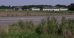
Airport in Randers, Denmark
| Randers Airport Randers Flyveplads | |||||||||||
|---|---|---|---|---|---|---|---|---|---|---|---|
 | |||||||||||
| Summary | |||||||||||
| Location | Randers, Denmark | ||||||||||
| Elevation AMSL | 154 ft / 47 m | ||||||||||
| Coordinates | 56°30′17.83″N 10°1′56.81″E / 56.5049528°N 10.0324472°E / 56.5049528; 10.0324472 | ||||||||||
| Runways | |||||||||||
| |||||||||||
Randers Airport (ICAO airport code EKRD) is an airport in Randers, Denmark. It is a municipally owned airfield, located near the village of Borup, 4.6 kilometers north of Randers Centrum. The site, which was first commissioned in 1967 has a 900-meter long and 23-meter wide asphalt 07-25 runway.
It is the second largest airport in eastern Jutland. The site is used primarily for private flights and training flights in smaller private planes, and also for small and medium corporate transports and taxi flights. The airport is home to Randers Flying Club. Randers Airport is also used as a link to other airports, including Billund and Aarhus. It has been considered extending Randers Airport to an international airport, but these plans have so far been shelved.
References
- "Home". randersflyveklub.dk.
- "Randers - EKRD". Archived from the original on 8 February 2012. Retrieved 28 February 2012.
| Randers | |
|---|---|
| Neighborhoods and suburbs | |
| Landmarks | |
| Churches | |
| Culture | |
| Museums | |
| Education | |
| Sports |
|
| Transport | |
This article is a stub. You can help Misplaced Pages by expanding it. |