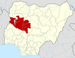
LGA and town in Niger State, Nigeria
| Rijau | |
|---|---|
| LGA and town | |
 | |
| Coordinates: 11°06′N 5°16′E / 11.100°N 5.267°E / 11.100; 5.267 | |
| Country | |
| State | Niger State |
| Government | |
| • Local Government Chairman and the Head of the Local Government Council | Bello Bako |
| Area | |
| • Total | 3,196 km (1,234 sq mi) |
| Population | |
| • Total | 176,053 |
| Time zone | UTC+1 (WAT) |
| 3-digit postal code prefix | 923 |
| ISO 3166 code | NG.NI.RI |
Rijau is a Local Government Area in Niger State, Nigeria. Its headquarters are in the town of Rijau.
It has an area of 3,196 km and a population of 176,053 at the 2006 census.
The postal code of the area is 923.
Climate
Throughout the wet season, the temperature rarely falls below 54°F or rises above 105°F, with a year-round range of 59°F to 100°F.
A daily maximum temperature of 97°F is typical during the 2.3-month hot season, which runs from February 16 to April 25. April has an average high temperature of 99°F and low temperature of 76°F, making it the hottest month of the year in Rijau.
A daily maximum temperature below 87°F is typical during the 3.3-month cool season, which runs from July 2 to October 10. December, with an average low of 60°F and high of 90°F, is the coldest month of the year in Rijau.
The average proportion of sky that is covered by clouds in Rijau varies significantly seasonally throughout the year.
Beginning about November 4 and lasting for four months, the clearer season in Rijau ends around March 5.
In Rijau, January is the clearest month of the year, with the sky remaining clear, mostly clear, or partly overcast 61% of the time.
Beginning around March 5 and lasting for 8.0 months, the cloudier period of the year ends around November 4.
May is the cloudiest month of the year in Rijau, with the sky being overcast or mostly cloudy 77% of the time on average.
References
- "Post Offices- with map of LGA". NIPOST. Archived from the original on October 7, 2009. Retrieved 2009-10-20.
- ^ "Rijau Climate, Weather By Month, Average Temperature (Nigeria) - Weather Spark". weatherspark.com. Retrieved 2023-09-10.
- ^ "Rijau, Niger, NG Climate Zone, Monthly Averages, Historical Weather Data". tcktcktck.org. Retrieved 2023-09-10.
- ^ "Current Local Time in Rijau, Niger, Nigeria". www.generalblue.com. Retrieved 2023-09-26.
- "Weather Archive Rijau". meteoblue. Retrieved 2023-09-26.
- "Rijau weather forecast for today". justweather.org. Retrieved 2023-09-26.
- Atlas, Weather. "Weather today - Rijau, Nigeria". Weather Atlas. Retrieved 2023-09-26.
| State capital: Minna | ||
| Local government areas |  | |
This Niger State, Nigeria location article is a stub. You can help Misplaced Pages by expanding it. |