| Rotelsee | |
|---|---|
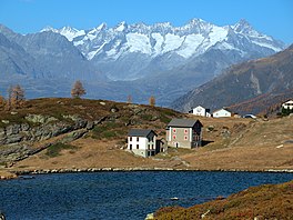
 Rotelsee at 2030 m Rotelsee at 2030 mWatershed between Po and Rhône at the trees on the hill | |
   | |
| Location | Simplon Pass, Valais |
| Coordinates | 46°14′39″N 8°1′51″E / 46.24417°N 8.03083°E / 46.24417; 8.03083 |
| Basin countries | Switzerland |
| Surface area | 1.2 ha (3.0 acres) |
| Surface elevation | 2,030 m (6,660 ft) |
Rotelsee (also Rotelschsee) is a lake near Simplon Pass in the canton of Valais, Switzerland. The water of the lake powers a small turbine in the monastery Simplon Hospice. The distance from the lake to the monastery is 220m and the difference of altitude is 30m.
Lake Rotel lies only 300m from the watershed between Po and Rhône The water of Rotelsee flows → Chrummbach → Diveria → Toce → Lake Maggiore → Ticino → Po → Adriatic Sea.
References
- Rotelschsee on Swiss Geo Map
- "Rotelsee (Simplon, VS) - schweizersee.ch". schweizersee.ch (in German). Retrieved 2018-11-23.
- Swiss Geo-maps
- Distance to watershed on Swiss Geo Map
This article related to a lake in Valais is a stub. You can help Misplaced Pages by expanding it. |