| This article includes a list of general references, but it lacks sufficient corresponding inline citations. Please help to improve this article by introducing more precise citations. (October 2018) (Learn how and when to remove this message) |
| Sakhizari Cliff Natural Monument | |
|---|---|
| IUCN category III (natural monument or feature) | |
 Sakhizari Cliff Natural Monument Sakhizari Cliff Natural Monument | |
  | |
| Nearest city | Stepantsminda, village Sioni |
| Coordinates | 42°34.279′N 44°33.299′E / 42.571317°N 44.554983°E / 42.571317; 44.554983 |
| Area | 3.36 km (1.30 sq mi) |
| Website | სახიზარის კლდის ბუნების ძეგლი |
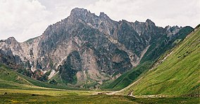
Sakhizari Cliff Natural Monument (Georgian: სახიზარის კლდის ბუნების ძეგლი) is a complex geologic structure that was formed due to abundant rainfall causing erosion of the volcanic mountain Khabarjina. Local population call this place "the ruins of the rocks" and in the past centuries at wartime villagers would seek refuge by climbing the cliffs when the enemy approached.
Scenic cliffs are located in Kazbegi Municipality in river Terek Gorge near village Sioni at 3136 meters above sea level.
It is part of Kazbegi Protected Areas along with Kazbegi National Park and five Natural Monuments:
- Sakhizari Cliff,
- Abano Mineral Lake,
- Truso Travertine,
- Jvari Pass Travertine,
- Keterisi Mineral Vaucluse.
References
- Sakhizari cliff in Georgia
- Kazbegi Support Programme for Protected Areas in the Caucasus - Georgia (SPPA-Georgia)
This Georgia location article is a stub. You can help Misplaced Pages by expanding it. |