You can help expand this article with text translated from the corresponding article in Spanish. (March 2021) Click for important translation instructions.
|
| Santa Marta ProvinceSanta Marta | |||||||||||||||
|---|---|---|---|---|---|---|---|---|---|---|---|---|---|---|---|
| Province | |||||||||||||||
| 1533 (1533)–1857 (1857) | |||||||||||||||
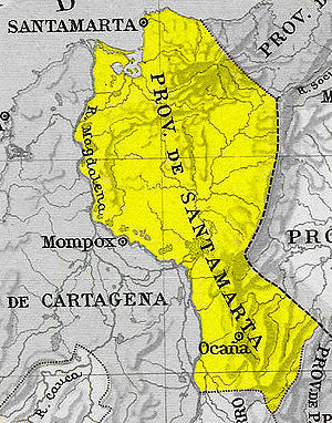
 Santa Marta Province in New Granada c. 1810 | |||||||||||||||
 Santa Marta Province in New Granada c. 1855 | |||||||||||||||
| Capital | Santa Marta | ||||||||||||||
| Demonym | Samari(a/o), Neogranadin(a/o) | ||||||||||||||
| Area | |||||||||||||||
| • Coordinates | 11°15′11″N 70°13′00″W / 11.25306°N 70.21667°W / 11.25306; -70.21667 | ||||||||||||||
| Population | |||||||||||||||
| • 1789 est. | 39,942 | ||||||||||||||
| • 1835 est. | 46,587 | ||||||||||||||
| • 1843 est. | 45,677 | ||||||||||||||
| • Type | Governorate | ||||||||||||||
| Historical era | Spanish colonization of the Americas Colombian War of Independence | ||||||||||||||
| • Established | February 16 (16-02) 1533 (1533) | ||||||||||||||
| • Dissolved | June 15 (15-06) 1857 (1857) | ||||||||||||||
| |||||||||||||||

Santa Marta Province was a province of New Granada.
References
- "Divisiones político administrativas del Virreinato de la Nueva Granada a finales del período colonial". Biblioteca Luis Ángel Arango. August 5, 2009. Archived from the original on August 5, 2009. Retrieved 2024-06-28.
- "Censo de población, años de 1835 y 1843". Colombia Estadística. 2013-11-28. Archived from the original on 2013-12-24. Retrieved 2024-06-28.
- "Censo de población, años de 1835 y 1843". Colombia Estadística. 2013-11-28. Archived from the original on 2013-12-24. Retrieved 2024-06-28.
11°15′11″N 70°13′00″W / 11.25306°N 70.21667°W / 11.25306; -70.21667
This Colombian history-related article is a stub. You can help Misplaced Pages by expanding it. |