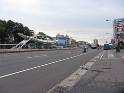
| Siaogang 小港區Kominato | |
|---|---|
| District | |
| Siaogang District | |
 | |
|
[REDACTED] 高雄市小港區公所 Siaogang District Office Kaohsiung City | |
| Nickname(s): Port Edge 港仔墘 (pinyin: Gǎngzaǐqián) | |
 | |
| Coordinates: 22°33′16″N 120°21′37″E / 22.554416°N 120.360176°E / 22.554416; 120.360176 | |
| Country | Taiwan |
| Region | Southern Taiwan |
| City | Kaohsiung City |
| Subdivisions |
List
|
| Area | |
| • Total | 45.4426 km (17.5455 sq mi) |
| Population | |
| • Total | 155,034 |
| • Density | 3,400/km (8,800/sq mi) |
| Website | hdao |
Siaogang District (Chinese: 小港區; Hanyu Pinyin: Xiǎogǎng Qū; Tongyong Pinyin: Siǎogǎng Cyu; Wade–Giles: Hsiao-kang Ch'ü; Pe̍h-ōe-jī: Sió-káng-khu lit: Small port District) is a district of Kaohsiung City in southern Taiwan. Before the merging of Kaohsiung City and Kaohsiung County in 2010, Siaogang was the southernmost district in Kaohsiung City. The second largest airport in Taiwan, Kaohsiung International Airport, is located in Siaogang.
History
Siaogang was developed during Dutch era. The Dutch built Ang Moh Harbor as an addition to Anping Harbor in Tainan. After the Dutch were defeated by Koxinga, they left Taiwan. Koxinga's government developed Taiwan as the last stronghold to revive the Ming Dynasty and prepare his troops to fight against the Qing dynasty. He sent one of his men, Wu Yanshang, to expand Siaogang. After the demise of Koxinga, his son and his grandson, the Qing managed to defeat the Kingdom of Tungning and annexed Taiwan.
Empire of Japan
In 1895, the Qing dynasty ceded Taiwan to Japan in the Treaty of Shimonoseki after losing the First Sino-Japanese War, and Siaogang was used to produce sugar for Japanese. In 1920, the original name of Kang-a-ki (Chinese: 港仔墘; Pe̍h-ōe-jī: Káng-á-kîⁿ) was changed, and the incorporated areas were administered as Kominato Village (小港庄) under Hōzan District, Takao Prefecture. As a heavy industry base in Taiwan during World War II, Siaogang was more heavily bombed by the Allied force than other parts of the city.
Republic of China
After the war and the handover of Taiwan from Japan to the Republic of China, Siaogang was administrated as Siaogang Township of Kaohsiung County, a third-level government of the Republic of China, under Taiwan Province. Siaogang was annexed by Kaohsiung City and become Siaogang District on 1 July 1979, when Kaohsiung City became a special municipality.
Geography


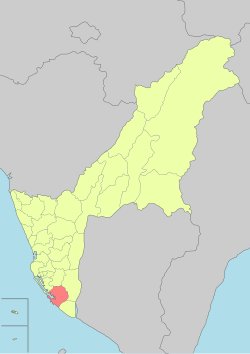
Siaogang is located in the southern part of Kaohsiung. It borders Cianjhen District to the north, Daliao District to the east, Linyuan District to the south, and the Taiwan Strait to the west.
Administrative divisions
The district consists of Xiaogang, Gangkou, Gangzheng, Gangqi, Gangming, Ganghou, Gangnan, Gangxing, Fenggong, Dianzhen, Daling, Erling, Sanling, Zhengling, Shunling, Liuling, Hongliang, Shantung, Jingdao, Jinan, Taishan, Shanming, Gaosong, Songjin, Songshan, Daping, Pingding, Kongzhai, Xiazhuang, Gezuo, Guilin, Zhongcuo, Fengming, Longfeng, Fengsen, Fenglin, Fengxing and Fengyuan Village.
Economy
See also: Linhai Industrial ParkAs far as the industry of Taiwan is concerned, Siaogang is one of the most important regions for the shipbuilding and steel industries. During the 1970s, the government spent 5 years carrying out Ten Major Construction Projects. Two companies resulting from the projects are based here: China Steel and CSBC Corporation, Taiwan. CPC Corporation, Taiwan also a part of the ten projects, has a major oil refinery facility located here. With the proximity of Kaohsiung Harbor, the products of these companies are exported worldwide. These products are also transported throughout the island via National Highway No. 1 (Taiwan), which terminates on the northern border of the district.
Education

Elementary schools
- Kaohsiung Municipal Siaogang Elementary School
- Kaohsiung Municipal Taiping Elementary School
- Kaohsiung Municipal Cingshan Elementary School
- Kaohsiung Municipal Pingding Elementary School
- Kaohsiung Municipal Fonglin Elementary School
- Kaohsiung Municipal Huashan Elementary School
- Kaohsiung Municipal Fongyang Elementary School
- Kaohsiung Municipal Huashan Elementary School
- Kaohsiung Municipal Ganghe Elementary School
- Kaohsiung Municipal Mingyi Elementary School
- Kaohsiung Municipal Erling Elementary School
- Kaohsiung Municipal Guilin Elementary School
- Kaohsiung Municipal Hanmin Elementary School
- Kaohsiung Municipal Fongming Elementary School
Junior high schools
- Kaohsiung Municipal Siaogang Junior High School
- Kaohsiung Municipal Jhongshan Junior High School
- Kaohsiung Municipal Mingyi Junior High School
- Kaohsiung Municipal Fonglin Junior High School
- Kahosiung Municipal Hospitality Junior High School
Senior High Schools
- The Affiliated Hospitality Senior High School of National Kaohsiung University of Hospitality and
Universities
Tourist attractions
- Dapingding Tropical Botanical Garden
- Hongmaogang Cultural Park
- Kaohsiung Astronomical Museum
- Kaohsiung Municipal Social Education Hall
- Kaohsiung Park: The name comes from its shape: it is built in the shape of Chinese character "高" (pronounced "Gao", meaning high, tall). It was once a lighthouse. After the building of second harbor of Kaohsiung, it was renewed and became a tourist attraction. The shape of the building is not only a Chinese character but also represent the spirit of Kaohsiung.
- Dalinpu Fenglin Temple, established in 1697 and often referred as the "Three Ong Yah Temple"
Infrastructure
Transportation

Air
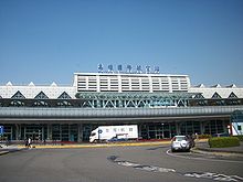
The Kaohsiung International Airport is located within the district
Railway
The district is accessible by Kaohsiung International Airport Station and Siaogang Station of the Kaohsiung Mass Rapid Transit.
Road (Siaogang station)
Notable natives
- Sung Chi-li, cult leader and geomancer
- Huang Ching-ya, politician
References
- ^ "Administrative Districts". Kaohsiung Municipal Government. 30 September 2016. Retrieved 4 April 2017.
Siaogang District:
- ^ "雙語詞彙". Kaohsiung Municipal Government (in Chinese (Taiwan) and English). Archived from the original on 15 September 2020. Retrieved 15 September 2020.
中文 英文 類別 提供單位
...
小港區 Siaogang District KCG - "HOME". Siaogang District Office Kaohsiung City. Retrieved 17 July 2019.
Siaogang District is located in the southeastern part of Kaohsiung City, bordered by Daliau Township to the east, Linyuan Township to the south, Fongshan City to the north, Cianjhen District to the northwest, and the Taiwan Strait to the southwest.
- Siaogang (Variant - V) at GEOnet Names Server, United States National Geospatial-Intelligence Agency
- Lee Hsin-fang; Sherry Hsiao (23 May 2019). "Cabinet rebuts Han's non-cooperation claims". Taipei Times. Retrieved 17 July 2019.
At a question-and-answer session at the Kaohsiung City Council on Tuesday, Chinese Nationalist Party (KMT) Kaohsiung City Councilor Huang Shao-ting (黃紹庭) suggested that due to a lack of cooperation from the central government, progress on major projects, such as the relocation of residents from Siaogang District's (小港) Dalinpu Village (大林蒲) and the construction of a new yellow line on the Kaohsiung Rapid Transit system, have come to a standstill since Han took office on Dec. 25 last year.
- "Organization and Functions of Kaohsiung City Government" (PDF). 2007. p. 173. Retrieved 14 July 2019.
Siaogang District
- KT Chang; E Wang; CP Kuo; MC Teng (2016). Geohazards Caused by Human Activity. p. 68. ISBN 978-953-51-2801-4 – via Google Books.
The cases discussed are as follows: Collapse of Chung Lin Road in Kaohsiung's Siaogang District - subsidence cracked Chung Lin Road for the second time within a year in the aftermath of Typhoon Dujuan in September 2015.
External links
| Districts in Taiwan | |||||||||||||
|---|---|---|---|---|---|---|---|---|---|---|---|---|---|
| List of townships/cities and districts in Taiwan | |||||||||||||
| Special municipalities |
| ||||||||||||
| Cities |
| ||||||||||||
| ¹ — Mountain indigenous district | |||||||||||||
| Kaohsiung City | |||||
|---|---|---|---|---|---|
| Districts | |||||
| Attractions | |||||
| Education |
| ||||
| ¹ — Mountain indigenous district | |||||