| Silver Lake | |
|---|---|
| lac Silver | |
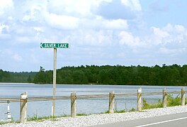
 View of Silver Lake from Ontario Highway 7, with Silver Lake Provincial Park in the background at right View of Silver Lake from Ontario Highway 7, with Silver Lake Provincial Park in the background at right | |
 | |
| Location | Lanark County and Frontenac County, Ontario |
| Coordinates | 44°49′39″N 76°35′58″W / 44.8275°N 76.5994°W / 44.8275; -76.5994 |
| Type | lake |
| Part of | Ottawa River drainage basin |
| Primary inflows | Wesleys Creek |
| Primary outflows | Silver Lake Creek |
| Basin countries | Canada |
| Max. length | 4.1 kilometres (2.5 mi) |
| Max. width | .8 kilometres (0.50 mi) |
| Surface area | 248.98 hectares (615 acres) |
| Surface elevation | 178 metres (584 ft) |
Silver Lake (French: lac Silver) is a lake in Tay Valley, Lanark County, and Central Frontenac, Frontenac County, in Eastern Ontario, Canada. It is the source of Silver Lake Creek and is in the Ottawa River drainage basin.
Geography
Silver Lake has an area of 248.98 hectares (615 acres) and lies at an elevation of 178 metres (584 ft) It is 4.1 kilometres (2.5 mi) long and .8 kilometres (0.50 mi) wide. Approximately the western two-thirds of the lake is in Central Frontenac, and the eastern third in Tay Valley. Ontario Highway 7 runs along the southern shore of the lake, which leads to the community of Maberly, 3 kilometres (1.9 mi) by road along Highway 7 to the east; it along with the dispersed rural community of Zealand, northwest of the lake, are the two nearest communities. The nearest larger centre is the town of Perth, 30 kilometres (19 mi) by road east along Highway 7.
The lake has one named inflow, Wesleys Creek, at the centre north; there are several unnamed secondary inflows. The primary outflow, at the eastern end of the lake, is Silver Lake Creek, which flows via the Fall River and the Mississippi River to Lac des Chats on the Ottawa River.
Recreation
Silver Lake Provincial Park is at the eastern end of the lake and encompasses the Silver Lake Creek outflow. The park has 100 campsites. It also has a sandy beach, and canoeing (rentals available), hiking and fishing are permitted; there is a boat ramp.
A road rest area at the middle of the southern shore of the lake on the north side of Highway 7 has a small sandy beach and picnic facilities.
A private camp, Silver Lake Wesleyan Camp, is operated by the Wesleyan Church on the north shore of the lake.
Natural history
The lake has northern pike, smallmouth bass, lake trout, yellow perch and sunfish. A short hiking trail in Silver Lake Provincial Park highlights the transition between two ecological zones: marsh and upland forest.
References
- ^ "Silver Lake". Geographical Names Data Base. Natural Resources Canada. Retrieved 2020-08-29.
- ^ "Toporama (on-line map and search)". Atlas of Canada. Natural Resources Canada. Retrieved 2020-08-29.
- ^ "Ontario Geonames GIS (on-line map and search)". Ontario Ministry of Natural Resources and Forestry. 2014. Retrieved 2020-08-29.
- ^ "Google Earth". Retrieved 2020-08-29.
- Restructured municipalities - Ontario map #5 (Map). Restructuring Maps of Ontario. Ontario Ministry of Municipal Affairs and Housing. 2006. Retrieved 2020-08-29.
- ^ Map 6 (PDF) (Map). 1 : 700,000. Official road map of Ontario. Ministry of Transportation of Ontario. 2018-01-01. Retrieved 2020-08-29.
- "Maberly". Geographical Names Data Base. Natural Resources Canada. Retrieved 2020-08-29.
- "Zealand". Geographical Names Data Base. Natural Resources Canada. Retrieved 2020-08-29.
- "Camping". Silver Lake Provincial Park. Ontario Parks. Retrieved 2020-08-29.
- ^ "Activities". Silver Lake Provincial Park. Ontario Parks. Retrieved 2020-08-29.
- "History & Perspective". Silver Lake Wesleyan Camp. Retrieved 2020-08-29.