| Sluice Boxes State Park | |
|---|---|
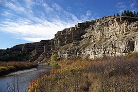
 Cliffs of the Belt Creek canyon Cliffs of the Belt Creek canyon | |
 | |
| Location | Cascade County, Montana, United States |
| Nearest town | Belt, Montana |
| Coordinates | 47°11′32″N 110°56′29″W / 47.19222°N 110.94139°W / 47.19222; -110.94139 |
| Area | 1,454 acres (5.88 km) |
| Elevation | 4,035 ft (1,230 m) |
| Designation | Montana state park |
| Established | 1974 |
| Visitors | 31,498 (in 2023) |
| Administrator | Montana Fish, Wildlife & Parks |
| Website | Sluice Boxes State Park |
Sluice Boxes State Park is a public recreation area in the Little Belt Mountains of Montana, United States, located twelve miles (19 km) south of Belt on the Kings Hill Scenic Byway. The state park is highlighted by large cliffs and ledges where the northernmost eight miles of the Belt Creek canyon winds out of the Little Belt Mountains. Remains of the area's mining and railroading days are found throughout the canyon. The park offers fishing, hiking, floating, picnicking, and backcountry camping.
References
- ^ "Sluice Boxes". Geographic Names Information System. United States Geological Survey, United States Department of the Interior.
- "Sluice Boxes State Park". Montana Kids. Travel Montana. Retrieved May 28, 2018.
- "Park Origin by Date". Montana State Parks. 2014. Archived from the original on January 1, 2020. Retrieved May 28, 2018.
- Montana Fish, Wildlife and Parks (May 6, 2024). "2023 Montana State Parks Annual Visitation Report" (PDF). fwp.mt.gov. Retrieved July 26, 2024.
- "Sluice Boxes State Park". Montana State Parks. Retrieved August 17, 2021.
External links
- Sluice Boxes State Park Montana Fish, Wildlife & Parks
- Sluice Boxes State Park Trail Map Montana Fish, Wildlife & Parks