| This article needs additional citations for verification. Please help improve this article by adding citations to reliable sources. Unsourced material may be challenged and removed. Find sources: "Smolare Falls" – news · newspapers · books · scholar · JSTOR (February 2024) (Learn how and when to remove this message) |
| Smolare Falls | |
|---|---|
 Smolare Falls Smolare Falls | |
| Location | Belasica, North Macedonia |
| Total height | 39.5 m |
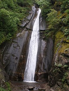
Smolare Falls (Macedonian: Смоларски Водопад) is a landform of Macedonia. Smolare is the tallest waterfall in the Republic of North Macedonia, falling from a height of 39.5 metres (129.5 feet). It is located above the village of Smolare in the Municipality of Novo Selo in the southeastern region of the country.
The waterfall is part of the Lomnica River and is located deep in Mount Belasica at an elevation of 630 metres. Crashing down the smooth, black rock face, and surrounded by 100-year-old beech trees, this waterfall is visited by tourists throughout the year.
-
Nature trail leading to Smolare Falls including 300 stone steps
-
The wooden bridge in front of Smolare Falls
References
- Statistical yearbook of the Republic of Macedonia (in Macedonian). Zavod. 2009. p. 22.
External links
- Information on Smolare Falls on the official website of the Municipality of Novo Selo
- Tourist information on the Exploring Macedonia webpage
41°21′55″N 22°53′57″E / 41.36528°N 22.89917°E / 41.36528; 22.89917
Categories: