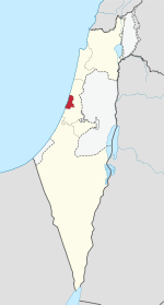
| Tel Aviv District | |
|---|---|
| - transcription(s) | |
| • Hebrew | מָחוֹז תֵּל אָבִיב |
| • Arabic | منطقة تل أبيب |
 Flag Flag | |
 | |
| Cities | 10 |
| Local Councils | 2 |
| Regional Councils | 0 |
| Principal city | Tel Aviv |
| Government | |
| • District Commissioner | Carmit Fenton |
| Area | |
| • Total | 186 km (72 sq mi) |
| Population | |
| • Total | 1,512,400 |
| • Density | 8,100/km (21,000/sq mi) |
| ISO 3166 code | IL-TA |
The Tel Aviv District (Hebrew: מָחוֹז תֵּל אָבִיב; Arabic: منطقة تل أبيب) is the geographically smallest yet also the most densely populated of the six administrative districts of Israel, with a population of 1.35 million residents. It is 98.9% Jewish and 1.10% Arab (0.7% Muslim, 0.4% Christian).

The district's capital is Tel Aviv, one of the two largest cities in Israel and the country's economic, business and technological capital. The metropolitan area created by the Tel Aviv district and its neighboring cities is locally named Gush Dan.
It is the only one of the six districts not adjacent to either the West Bank or an international border, being surrounded on the north, east, and south by the Central District and on the west by the Mediterranean Sea. The population density of the Tel Aviv district is 7,259/km.
Administrative local authorities
| Cities | Local Councils |
|---|---|
- Notes
- ^ Part of the Tel Aviv Natural Region.
- ^ Part of the Holon Natural Region.
- ^ Part of the Ramat Gan Natural Region.

List of cities and towns in Tel Aviv district
| Pop Rank | Name | Population | Land Area (Dunams) |
Founded | City Since |
Natural Region |
|---|---|---|---|---|---|---|
| 1 | Tel Aviv-Yafo | 438,818 | 51,788 | 1909 | 1921 1950 |
Tel Aviv |
| 2 | Holon | 190,838 | 18,927 | 1940 | 1950 | Holon |
| 3 | Bnei Brak | 188,964 | 7,343 | 1924 | 1950 | Ramat Gan |
| 4 | Ramat Gan | 153,674 | 13,229 | 1921 | 1950 | Ramat Gan |
| 5 | Bat Yam | 129,100 | 8,167 | 1926 | 1958 | Holon |
| 6 | Herzliya | 93,116 | 21,850 | 1924 | 1960 | Tel Aviv |
| 7 | Giv'atayim | 58,509 | 3,246 | 1922 | 1959 | Ramat Gan |
| 8 | Ramat HaSharon | 45,066 | 16,792 | 1923 | 2002 | Tel Aviv |
| 9 | Kiryat Ono | 38,596 | 4,112 | 1939 | 1992 | Ramat Gan |
| 10 | Or Yehuda | 36,536 | 5,141 | 1949 | 1988 | Ramat Gan |
| 11 | Azor | 12,570 | 2,415 | 1948 | Holon | |
| 12 | Kfar Shmaryahu | 1,911 | 2,665 | 1937 | Tel Aviv | |
| 13 | Glil Yam (Hof HaSharon RC) | 500 | - | 1943 | Tel Aviv | |
| 14 | Mikveh Israel | 432 | 3,300 | 1870 | Holon | |
| A 1921 Official establishment of Tel Aviv Municipality B 1950 Merger of municipalities of Tel Aviv and Jaffa | ||||||
See also
References
- "בעלי תפקידים במשרד הפנים".
- Transfer of Power (District Commissioners and District Officers) Law, 5724-1964, Laws of the State of Israel vol. 18 no 38. (pp. 70-71)
- "Localities by Population, by District, Sub-District and Type of Locality". Israel Central Bureau of Statistics.
- "Oops, Something is wrong" (PDF). www.cbs.gov.il.
- ""8. אוכלוסייה ביישובים ובאזורים סטטיסטיים, לפי דת, סוף 2019"". Central Bureau of Statistics (Israel).
External links
- [REDACTED] Media related to Tel Aviv District at Wikimedia Commons
| Places adjacent to Tel Aviv District | ||||||||||||||||
|---|---|---|---|---|---|---|---|---|---|---|---|---|---|---|---|---|
| ||||||||||||||||
| Districts of Israel | |
|---|---|
| Tel Aviv District | ||
|---|---|---|
| Cities |  | |
| Local councils | ||
| ||
| Administrative jurisdiction types of Israel | |
|---|---|
| First level | |
| Second level |
|
| Third level |
|
| Fourth level | |
32°05′N 34°48′E / 32.083°N 34.800°E / 32.083; 34.800
This geography of Israel article is a stub. You can help Misplaced Pages by expanding it. |