| Ten Boer | |
|---|---|
| Village, former municipality | |
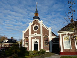
 Church in Thesinge Church in Thesinge | |
 Flag Flag | |
 Location in Groningen Location in Groningen | |
  | |
| Coordinates: 53°16′37″N 6°41′40″E / 53.27696°N 6.69432°E / 53.27696; 6.69432 | |
| Country | Netherlands |
| Province | Groningen |
| Municipality | Groningen |
| Merged | 2019 |
| Area | |
| • Total | 9.06 km (3.50 sq mi) |
| Elevation | 1 m (3 ft) |
| Population | |
| • Total | 4,645 |
| • Density | 510/km (1,300/sq mi) |
| Time zone | UTC+1 (CET) |
| • Summer (DST) | UTC+2 (CEST) |
| Postcode | 9791 |
| Area code | 050 |
Ten Boer (Dutch pronunciation: [tɛmˈbuːr] ) is a village and a former municipality in the northeastern Netherlands, in the province of Groningen. The municipality had a population of data missing in 2021; the village of Ten Boer has approximately 4,600 inhabitants. In 2019, it was merged into municipality of Groningen.
History
The village was first mentioned in 1301 as "conventum de Bure", and means "near the house". Ten Boer is a terp (artificial living hill) village on a grid structure. In 1301, a Benedictine monastery for nuns was established in Ten Boer. In 1485, it was incorporated into the monastery of Thesinge. Around 1425, the Damsterdiep [nl], a canal from Groningen to Delfzijl, was dug and the village received its current shape.
The Dutch Reformed church is the former monastery church, and dates from the 13th century. The church was modified in 1565. The tower was demolished around 1800, and in 1810, a ridge turret was placed on the roof instead.
Ten Boer was home to 279 people in 1840. The former town hall is an L-shaped building with tower from 1911. It was influenced by Berlage and Jugendstil. Ten Boer was an independent municipality until 2019 when it was merged into Groningen.
Former population centres
Garmerwolde, Lellens, Sint Annen, Ten Boer, Ten Post, Thesinge, Winneweer, Wittewierum and Woltersum.
Notable people from Ten Boer
- Dirk van der Borg (born 1955), mayor of Graafstroom and Molenwaard
- Paul Drewes (born 1982), Olympic rower
- Hendrik Nienhuis (1790-1862), jurist and parliament member
- Remco van der Schaaf (born 1979), football player
Gallery
-
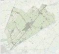
 Dutch topographic map of the municipality of Ten Boer, June 2015
-
 Drawing bridge near the Wolddijk-Stadsweg
-
 Former town hall
-
 Poorhouse
References
- ^ "Kerncijfers wijken en buurten 2021". Central Bureau of Statistics. Retrieved 8 April 2022.
4 entries
- "Postcodetool for 9791CT". Actueel Hoogtebestand Nederland (in Dutch). Het Waterschapshuis. Retrieved 4 February 2014.
- ^ "Ten Boer". Plaatsengids (in Dutch). Retrieved 8 April 2022.
- "Ten Boer - (geografische naam)". Etymologiebank (in Dutch). Retrieved 8 April 2022.
- ^ Ronald Stenvert & Redmer Alma (1998). "Ten Boer" (in Dutch). Zwolle: Waanders. ISBN 90 400 9258 3. Retrieved 7 April 2022.
- "Klooster". Stichting Pelgrimeren in Groningen (in Dutch). Retrieved 8 April 2022.
External links
- [REDACTED] Media related to Ten Boer at Wikimedia Commons
| Places adjacent to Ten Boer | ||||||||||||||||
|---|---|---|---|---|---|---|---|---|---|---|---|---|---|---|---|---|
| ||||||||||||||||
| Populated places in the municipality of Groningen | |
|---|---|
| Towns | |
| Villages | |
| Hamlets | |
| List of cities, towns and villages in Groningen | |