| Tenosique Municipality | |
|---|---|
| Municipality | |
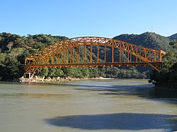
 "Boca del Cerro" bridge located in the municipality "Boca del Cerro" bridge located in the municipality | |
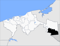
 Location of the municipality in Tabasco. Location of the municipality in Tabasco. | |
| Country | |
| State | Tabasco |
| Time zone | UTC-6 (Central Standard Time) |
| • Summer (DST) | UTC-5 (Central Daylight Time) |
Tenosique Municipality is a municipality in the Mexican state of Tabasco in south-eastern Mexico. The municipal seat is the town of Tenosique.
Geography
The municipality has an area of 2,098.1 km (810.1 sq mi) and includes many small outlying communities.
Cañón del Usumacinta Flora and Fauna Protection Area is located in the municipality.
References
- "-". Enciclopedia de los Municipios de México. Instituto Nacional para el Federalismo y el Desarrollo Municipal. Retrieved January 4, 2010.
This article about a location in the Mexican state of Tabasco is a stub. You can help Misplaced Pages by expanding it. |
17°28′N 91°25′W / 17.467°N 91.417°W / 17.467; -91.417
Categories: