| This article does not cite any sources. Please help improve this article by adding citations to reliable sources. Unsourced material may be challenged and removed. Find sources: "Torotoro, Bolivia" – news · newspapers · books · scholar · JSTOR (December 2009) (Learn how and when to remove this message) |
| Toro Toro | |
|---|---|
| Town | |
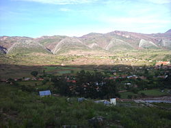
 the town Toro Toro the town Toro Toro | |
 | |
| Coordinates: 18°8′S 65°46′W / 18.133°S 65.767°W / -18.133; -65.767 | |
| Country | |
| Department | Potosí Department |
| Province | Charcas Province |
| Municipality | Toro Toro Municipality |
| Population | |
| • Total | 676 |
| Time zone | UTC-4 (BOT) |
Torotoro (or Toro Toro) is a town in the Charcas Province, Potosí Department, Bolivia.
Torotoro was founded in the late colonial period by mestizo migrants from Cochabamba and legally confirmed as a municipality (municipio) on 21 November 1883. The municipality has an area of 1,169 km² and a population of 10,535 (2001).
Torotoro lies at an altitude of 2,676 m. It can only be reached by road from Estancia Sucusuma at the Río Caine. The town is at the centre of Torotoro National Park. It is 140 km south of Cochabamba.
18°8′3″S 65°45′48″W / 18.13417°S 65.76333°W / -18.13417; -65.76333
| Capital: Potosí | ||
| Provinces |  | |
| Municipalities (and seats) |
| |